You are here: Home > Network List > IU - Global Seismograph Network (GSN - IRIS/USGS) Stations List
> Station KMBO Kilima Mbogo, Kenya > Earthquake Result Viewer
KMBO Kilima Mbogo, Kenya - Earthquake Result Viewer

| Earthquake location: |
Nicobar Islands, India Region |
| Earthquake latitude/longitude: |
8.3/91.8 |
| Earthquake time(UTC): |
2018/01/25 (025) 01:15:58 GMT |
| Earthquake Depth: |
10 km |
| Earthquake Magnitude: |
5.9 Mww |
| Earthquake Catalog/Contributor: |
NEIC PDE/us |
|
| Network: |
IU Global Seismograph Network (GSN - IRIS/USGS) |
| Station: |
KMBO Kilima Mbogo, Kenya |
| Lat/Lon: |
1.13 S/37.25 E |
| Elevation: |
1950 m |
|
| Distance: |
55.2 deg |
| Az: |
262.844 deg |
| Baz: |
79.178 deg |
| Ray Param: |
0.06498289 |
| Estimated Moho Depth: |
49.25 km |
| Estimated Crust Vp/Vs: |
1.69 |
| Assumed Crust Vp: |
6.601 km/s |
| Estimated Crust Vs: |
3.9 km/s |
| Estimated Crust Poisson's Ratio: |
0.23 |
|
| Radial Match: |
91.418686 % |
| Radial Bump: |
275 |
| Transverse Match: |
71.01068 % |
| Transverse Bump: |
400 |
| SOD ConfigId: |
2546091 |
| Insert Time: |
2018-02-08 01:17:18.128 +0000 |
| GWidth: |
2.5 |
| Max Bumps: |
400 |
| Tol: |
0.001 |
|
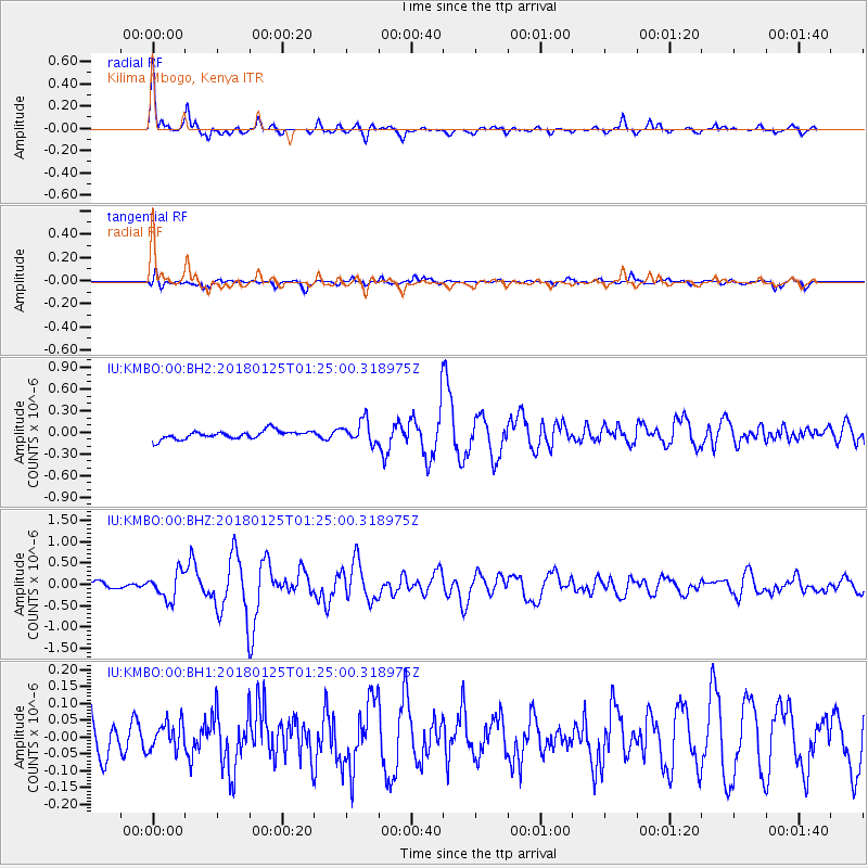
Signal To Noise
| Channel | StoN | STA | LTA |
| IU:KMBO:00:BHZ:20180125T01:25:00.318975Z | 4.6962895 | 3.1369308E-7 | 6.6795934E-8 |
| IU:KMBO:00:BH1:20180125T01:25:00.318975Z | 0.56169987 | 4.058488E-8 | 7.225368E-8 |
| IU:KMBO:00:BH2:20180125T01:25:00.318975Z | 2.6764636 | 1.5274165E-7 | 5.7068455E-8 |
| Arrivals |
| Ps | 5.5 SECOND |
| PpPs | 19 SECOND |
| PsPs/PpSs | 24 SECOND |


