You are here: Home > Network List > N4 - Central and EAstern US Network Stations List
> Station SUSD Miller, SD, USA > Earthquake Result Viewer
SUSD Miller, SD, USA - Earthquake Result Viewer
| Earthquake location: |
South Of Alaska |
| Earthquake latitude/longitude: |
55.4/-157.0 |
| Earthquake time(UTC): |
2021/07/30 (211) 03:52:15 GMT |
| Earthquake Depth: |
33 km |
| Earthquake Magnitude: |
5.5 Mww |
| Earthquake Catalog/Contributor: |
NEIC PDE/ak |
|
| Network: |
N4 Central and EAstern US Network |
| Station: |
SUSD Miller, SD, USA |
| Lat/Lon: |
44.44 N/98.96 W |
| Elevation: |
520 m |
|
| Distance: |
37.9 deg |
| Az: |
81.838 deg |
| Baz: |
307.883 deg |
| Ray Param: |
0.07583008 |
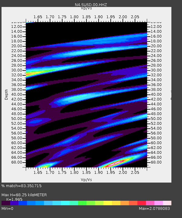
| Estimated Moho Depth: |
68.25 km |
| Estimated Crust Vp/Vs: |
1.97 |
| Assumed Crust Vp: |
6.53 km/s |
| Estimated Crust Vs: |
3.323 km/s |
| Estimated Crust Poisson's Ratio: |
0.33 |
|
| Radial Match: |
83.351715 % |
| Radial Bump: |
370 |
| Transverse Match: |
69.979294 % |
| Transverse Bump: |
400 |
| SOD ConfigId: |
25131211 |
| Insert Time: |
2021-08-13 04:03:19.001 +0000 |
| GWidth: |
2.5 |
| Max Bumps: |
400 |
| Tol: |
0.001 |
|

Signal To Noise
| Channel | StoN | STA | LTA |
| N4:SUSD:00:HHZ:20210730T03:58:58.699012Z | 3.4541488 | 2.646755E-7 | 7.662538E-8 |
| N4:SUSD:00:HH1:20210730T03:58:58.699012Z | 1.4625832 | 1.8435071E-7 | 1.260446E-7 |
| N4:SUSD:00:HH2:20210730T03:58:58.699012Z | 2.7604823 | 3.1744548E-7 | 1.14996375E-7 |
| Arrivals |
| Ps | 11 SECOND |
| PpPs | 29 SECOND |
| PsPs/PpSs | 40 SECOND |


