You are here: Home > Network List > AE - Arizona Broadband Seismic Network Stations List
> Station PRCT Prescott > Earthquake Result Viewer
PRCT Prescott - Earthquake Result Viewer
| Earthquake location: |
Peru-Ecuador Border Region |
| Earthquake latitude/longitude: |
-4.9/-80.6 |
| Earthquake time(UTC): |
2021/07/30 (211) 17:10:19 GMT |
| Earthquake Depth: |
33 km |
| Earthquake Magnitude: |
6.2 Mww |
| Earthquake Catalog/Contributor: |
NEIC PDE/us |
|
| Network: |
AE Arizona Broadband Seismic Network |
| Station: |
PRCT Prescott |
| Lat/Lon: |
35.06 N/112.71 W |
| Elevation: |
1410 m |
|
| Distance: |
49.9 deg |
| Az: |
325.271 deg |
| Baz: |
136.222 deg |
| Ray Param: |
0.06832233 |
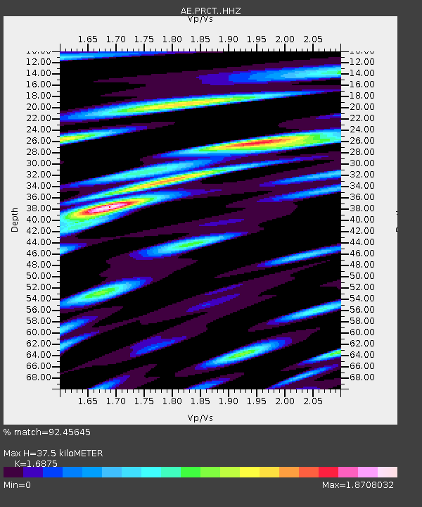
| Estimated Moho Depth: |
37.5 km |
| Estimated Crust Vp/Vs: |
1.69 |
| Assumed Crust Vp: |
6.276 km/s |
| Estimated Crust Vs: |
3.719 km/s |
| Estimated Crust Poisson's Ratio: |
0.23 |
|
| Radial Match: |
92.45645 % |
| Radial Bump: |
400 |
| Transverse Match: |
79.02074 % |
| Transverse Bump: |
400 |
| SOD ConfigId: |
25131211 |
| Insert Time: |
2021-08-13 17:10:53.577 +0000 |
| GWidth: |
2.5 |
| Max Bumps: |
400 |
| Tol: |
0.001 |
|

Signal To Noise
| Channel | StoN | STA | LTA |
| AE:PRCT: :HHZ:20210730T17:18:39.409997Z | 50.837234 | 3.1201657E-6 | 6.1375594E-8 |
| AE:PRCT: :HHN:20210730T17:18:39.409997Z | 42.09175 | 1.7180511E-6 | 4.081681E-8 |
| AE:PRCT: :HHE:20210730T17:18:39.409997Z | 26.059412 | 1.5517985E-6 | 5.9548487E-8 |
| Arrivals |
| Ps | 4.4 SECOND |
| PpPs | 15 SECOND |
| PsPs/PpSs | 20 SECOND |


