You are here: Home > Network List > AK - Alaska Regional Network Stations List
> Station K15K Wolf Creek Mountain, AK, USA > Earthquake Result Viewer
K15K Wolf Creek Mountain, AK, USA - Earthquake Result Viewer
| Earthquake location: |
Peru-Ecuador Border Region |
| Earthquake latitude/longitude: |
-4.9/-80.6 |
| Earthquake time(UTC): |
2021/07/30 (211) 17:10:19 GMT |
| Earthquake Depth: |
33 km |
| Earthquake Magnitude: |
6.2 Mww |
| Earthquake Catalog/Contributor: |
NEIC PDE/us |
|
| Network: |
AK Alaska Regional Network |
| Station: |
K15K Wolf Creek Mountain, AK, USA |
| Lat/Lon: |
62.29 N/161.53 W |
| Elevation: |
346 m |
|
| Distance: |
90.1 deg |
| Az: |
332.513 deg |
| Baz: |
100.301 deg |
| Ray Param: |
0.041718807 |
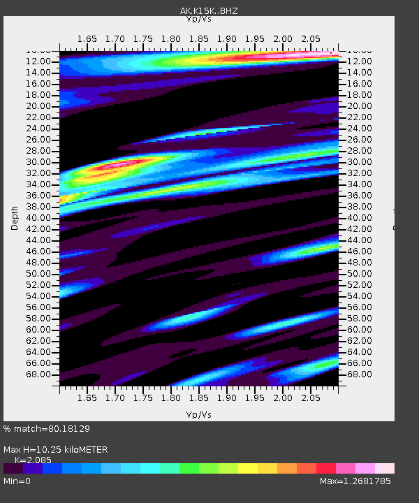
| Estimated Moho Depth: |
10.25 km |
| Estimated Crust Vp/Vs: |
2.09 |
| Assumed Crust Vp: |
6.276 km/s |
| Estimated Crust Vs: |
3.01 km/s |
| Estimated Crust Poisson's Ratio: |
0.35 |
|
| Radial Match: |
80.18129 % |
| Radial Bump: |
326 |
| Transverse Match: |
73.591125 % |
| Transverse Bump: |
358 |
| SOD ConfigId: |
25131211 |
| Insert Time: |
2021-08-13 17:13:18.715 +0000 |
| GWidth: |
2.5 |
| Max Bumps: |
400 |
| Tol: |
0.001 |
|

Signal To Noise
| Channel | StoN | STA | LTA |
| AK:K15K: :BHZ:20210730T17:22:44.780022Z | 22.485235 | 1.6271233E-6 | 7.2364074E-8 |
| AK:K15K: :BHN:20210730T17:22:44.780022Z | 1.0717013 | 1.5227874E-7 | 1.4209066E-7 |
| AK:K15K: :BHE:20210730T17:22:44.780022Z | 6.124903 | 6.073179E-7 | 9.91555E-8 |
| Arrivals |
| Ps | 1.8 SECOND |
| PpPs | 5.0 SECOND |
| PsPs/PpSs | 6.8 SECOND |


