You are here: Home > Network List > AK - Alaska Regional Network Stations List
> Station NEA2 Nenana, AK, USA > Earthquake Result Viewer
NEA2 Nenana, AK, USA - Earthquake Result Viewer
| Earthquake location: |
Peru-Ecuador Border Region |
| Earthquake latitude/longitude: |
-4.9/-80.6 |
| Earthquake time(UTC): |
2021/07/30 (211) 17:10:19 GMT |
| Earthquake Depth: |
33 km |
| Earthquake Magnitude: |
6.2 Mww |
| Earthquake Catalog/Contributor: |
NEIC PDE/us |
|
| Network: |
AK Alaska Regional Network |
| Station: |
NEA2 Nenana, AK, USA |
| Lat/Lon: |
64.59 N/149.07 W |
| Elevation: |
450 m |
|
| Distance: |
85.4 deg |
| Az: |
336.259 deg |
| Baz: |
111.591 deg |
| Ray Param: |
0.044770394 |
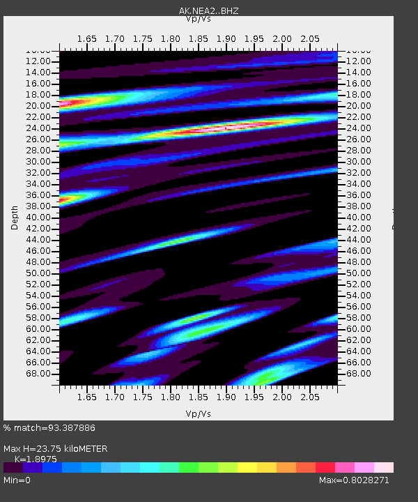
| Estimated Moho Depth: |
23.75 km |
| Estimated Crust Vp/Vs: |
1.90 |
| Assumed Crust Vp: |
6.566 km/s |
| Estimated Crust Vs: |
3.46 km/s |
| Estimated Crust Poisson's Ratio: |
0.31 |
|
| Radial Match: |
93.387886 % |
| Radial Bump: |
400 |
| Transverse Match: |
87.30309 % |
| Transverse Bump: |
400 |
| SOD ConfigId: |
25131211 |
| Insert Time: |
2021-08-13 17:14:06.338 +0000 |
| GWidth: |
2.5 |
| Max Bumps: |
400 |
| Tol: |
0.001 |
|

Signal To Noise
| Channel | StoN | STA | LTA |
| AK:NEA2: :BHZ:20210730T17:22:22.067986Z | 33.36978 | 2.4299661E-6 | 7.281936E-8 |
| AK:NEA2: :BHN:20210730T17:22:22.067986Z | 8.199381 | 4.4487325E-7 | 5.4256937E-8 |
| AK:NEA2: :BHE:20210730T17:22:22.067986Z | 16.713606 | 7.48998E-7 | 4.481367E-8 |
| Arrivals |
| Ps | 3.3 SECOND |
| PpPs | 10 SECOND |
| PsPs/PpSs | 14 SECOND |


