You are here: Home > Network List > AK - Alaska Regional Network Stations List
> Station SCM Sheep Mountain > Earthquake Result Viewer
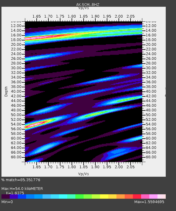
SCM Sheep Mountain - Earthquake Result Viewer
| Earthquake location: |
Peru-Ecuador Border Region |
| Earthquake latitude/longitude: |
-4.9/-80.6 |
| Earthquake time(UTC): |
2021/07/30 (211) 17:10:19 GMT |
| Earthquake Depth: |
33 km |
| Earthquake Magnitude: |
6.2 Mww |
| Earthquake Catalog/Contributor: |
NEIC PDE/us |
|
| Network: |
AK Alaska Regional Network |
| Station: |
SCM Sheep Mountain |
| Lat/Lon: |
61.83 N/147.33 W |
| Elevation: |
1056 m |
|
| Distance: |
83.6 deg |
| Az: |
333.983 deg |
| Baz: |
112.926 deg |
| Ray Param: |
0.046038765 |
| Estimated Moho Depth: |
54.0 km |
| Estimated Crust Vp/Vs: |
1.64 |
| Assumed Crust Vp: |
6.566 km/s |
| Estimated Crust Vs: |
4.01 km/s |
| Estimated Crust Poisson's Ratio: |
0.20 |
|
| Radial Match: |
85.351776 % |
| Radial Bump: |
400 |
| Transverse Match: |
74.55383 % |
| Transverse Bump: |
400 |
| SOD ConfigId: |
25131211 |
| Insert Time: |
2021-08-13 17:14:58.791 +0000 |
| GWidth: |
2.5 |
| Max Bumps: |
400 |
| Tol: |
0.001 |
|

Signal To Noise
| Channel | StoN | STA | LTA |
| AK:SCM: :BHZ:20210730T17:22:13.108025Z | 29.368698 | 2.5050188E-6 | 8.529553E-8 |
| AK:SCM: :BHN:20210730T17:22:13.108025Z | 8.991689 | 6.4772325E-7 | 7.2035775E-8 |
| AK:SCM: :BHE:20210730T17:22:13.108025Z | 14.869044 | 7.5749693E-7 | 5.094456E-8 |
| Arrivals |
| Ps | 5.4 SECOND |
| PpPs | 21 SECOND |
| PsPs/PpSs | 26 SECOND |


