You are here: Home > Network List > AK - Alaska Regional Network Stations List
> Station SKN Skwentna > Earthquake Result Viewer
SKN Skwentna - Earthquake Result Viewer
| Earthquake location: |
Peru-Ecuador Border Region |
| Earthquake latitude/longitude: |
-4.9/-80.6 |
| Earthquake time(UTC): |
2021/07/30 (211) 17:10:19 GMT |
| Earthquake Depth: |
33 km |
| Earthquake Magnitude: |
6.2 Mww |
| Earthquake Catalog/Contributor: |
NEIC PDE/us |
|
| Network: |
AK Alaska Regional Network |
| Station: |
SKN Skwentna |
| Lat/Lon: |
61.98 N/151.53 W |
| Elevation: |
603 m |
|
| Distance: |
85.5 deg |
| Az: |
333.405 deg |
| Baz: |
109.169 deg |
| Ray Param: |
0.044678733 |
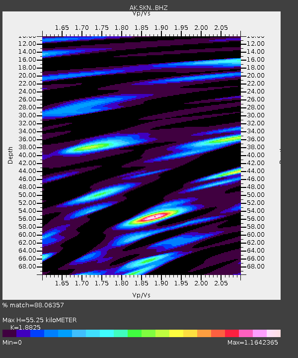
| Estimated Moho Depth: |
55.25 km |
| Estimated Crust Vp/Vs: |
1.88 |
| Assumed Crust Vp: |
6.302 km/s |
| Estimated Crust Vs: |
3.347 km/s |
| Estimated Crust Poisson's Ratio: |
0.30 |
|
| Radial Match: |
88.06357 % |
| Radial Bump: |
400 |
| Transverse Match: |
82.07546 % |
| Transverse Bump: |
400 |
| SOD ConfigId: |
25131211 |
| Insert Time: |
2021-08-13 17:15:02.131 +0000 |
| GWidth: |
2.5 |
| Max Bumps: |
400 |
| Tol: |
0.001 |
|

Signal To Noise
| Channel | StoN | STA | LTA |
| AK:SKN: :BHZ:20210730T17:22:22.708001Z | 35.8604 | 2.4268304E-6 | 6.767438E-8 |
| AK:SKN: :BHN:20210730T17:22:22.708001Z | 5.6856003 | 3.772166E-7 | 6.6345955E-8 |
| AK:SKN: :BHE:20210730T17:22:22.708001Z | 14.119496 | 9.340111E-7 | 6.6150456E-8 |
| Arrivals |
| Ps | 7.9 SECOND |
| PpPs | 25 SECOND |
| PsPs/PpSs | 33 SECOND |


