You are here: Home > Network List > AV - Alaska Volcano Observatory Stations List
> Station AUJK Augustine Jurgen Kienle, Cook Inlet, Alaska > Earthquake Result Viewer
AUJK Augustine Jurgen Kienle, Cook Inlet, Alaska - Earthquake Result Viewer
| Earthquake location: |
Peru-Ecuador Border Region |
| Earthquake latitude/longitude: |
-4.9/-80.6 |
| Earthquake time(UTC): |
2021/07/30 (211) 17:10:19 GMT |
| Earthquake Depth: |
33 km |
| Earthquake Magnitude: |
6.2 Mww |
| Earthquake Catalog/Contributor: |
NEIC PDE/us |
|
| Network: |
AV Alaska Volcano Observatory |
| Station: |
AUJK Augustine Jurgen Kienle, Cook Inlet, Alaska |
| Lat/Lon: |
59.35 N/153.41 W |
| Elevation: |
377 m |
|
| Distance: |
85.6 deg |
| Az: |
330.599 deg |
| Baz: |
107.312 deg |
| Ray Param: |
0.044640113 |
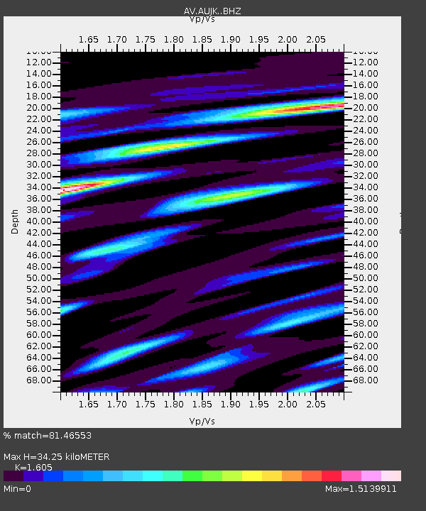
| Estimated Moho Depth: |
34.25 km |
| Estimated Crust Vp/Vs: |
1.61 |
| Assumed Crust Vp: |
5.989 km/s |
| Estimated Crust Vs: |
3.732 km/s |
| Estimated Crust Poisson's Ratio: |
0.18 |
|
| Radial Match: |
81.46553 % |
| Radial Bump: |
400 |
| Transverse Match: |
60.722717 % |
| Transverse Bump: |
400 |
| SOD ConfigId: |
25131211 |
| Insert Time: |
2021-08-13 17:16:02.118 +0000 |
| GWidth: |
2.5 |
| Max Bumps: |
400 |
| Tol: |
0.001 |
|
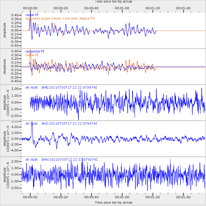
Signal To Noise
| Channel | StoN | STA | LTA |
| AV:AUJK: :BHZ:20210730T17:22:22.979974Z | 9.982103 | 2.1587402E-6 | 2.1626107E-7 |
| AV:AUJK: :BHN:20210730T17:22:22.979974Z | 1.2402521 | 7.864046E-7 | 6.3406833E-7 |
| AV:AUJK: :BHE:20210730T17:22:22.979974Z | 1.5401995 | 9.670807E-7 | 6.2789314E-7 |
| Arrivals |
| Ps | 3.5 SECOND |
| PpPs | 15 SECOND |
| PsPs/PpSs | 18 SECOND |


