You are here: Home > Network List > AV - Alaska Volcano Observatory Stations List
> Station ILLG Iliamna Volcano, Alaska > Earthquake Result Viewer
ILLG Iliamna Volcano, Alaska - Earthquake Result Viewer
| Earthquake location: |
Peru-Ecuador Border Region |
| Earthquake latitude/longitude: |
-4.9/-80.6 |
| Earthquake time(UTC): |
2021/07/30 (211) 17:10:19 GMT |
| Earthquake Depth: |
33 km |
| Earthquake Magnitude: |
6.2 Mww |
| Earthquake Catalog/Contributor: |
NEIC PDE/us |
|
| Network: |
AV Alaska Volcano Observatory |
| Station: |
ILLG Iliamna Volcano, Alaska |
| Lat/Lon: |
60.07 N/152.96 W |
| Elevation: |
968 m |
|
| Distance: |
85.6 deg |
| Az: |
331.358 deg |
| Baz: |
107.759 deg |
| Ray Param: |
0.044640105 |
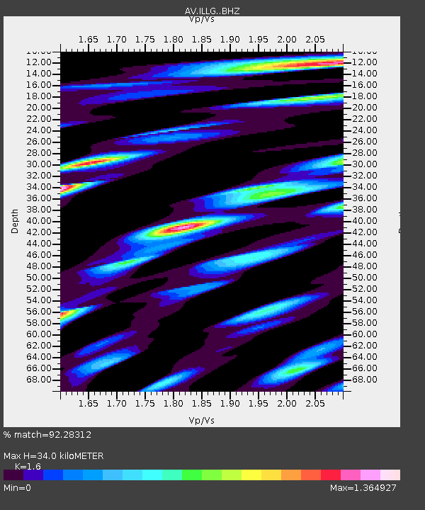
| Estimated Moho Depth: |
34.0 km |
| Estimated Crust Vp/Vs: |
1.60 |
| Assumed Crust Vp: |
6.566 km/s |
| Estimated Crust Vs: |
4.104 km/s |
| Estimated Crust Poisson's Ratio: |
0.18 |
|
| Radial Match: |
92.28312 % |
| Radial Bump: |
400 |
| Transverse Match: |
90.098816 % |
| Transverse Bump: |
400 |
| SOD ConfigId: |
25131211 |
| Insert Time: |
2021-08-13 17:16:29.572 +0000 |
| GWidth: |
2.5 |
| Max Bumps: |
400 |
| Tol: |
0.001 |
|

Signal To Noise
| Channel | StoN | STA | LTA |
| AV:ILLG: :BHZ:20210730T17:22:22.979974Z | 26.321108 | 1.0537024E-6 | 4.00326E-8 |
| AV:ILLG: :BHN:20210730T17:22:22.979974Z | 11.091073 | 5.895053E-7 | 5.315133E-8 |
| AV:ILLG: :BHE:20210730T17:22:22.979974Z | 19.388021 | 8.778112E-7 | 4.5275954E-8 |
| Arrivals |
| Ps | 3.2 SECOND |
| PpPs | 13 SECOND |
| PsPs/PpSs | 16 SECOND |


