You are here: Home > Network List > AV - Alaska Volcano Observatory Stations List
> Station STLK Strandline Lake, Regional Station, Alaska > Earthquake Result Viewer
STLK Strandline Lake, Regional Station, Alaska - Earthquake Result Viewer
| Earthquake location: |
Peru-Ecuador Border Region |
| Earthquake latitude/longitude: |
-4.9/-80.6 |
| Earthquake time(UTC): |
2021/07/30 (211) 17:10:19 GMT |
| Earthquake Depth: |
33 km |
| Earthquake Magnitude: |
6.2 Mww |
| Earthquake Catalog/Contributor: |
NEIC PDE/us |
|
| Network: |
AV Alaska Volcano Observatory |
| Station: |
STLK Strandline Lake, Regional Station, Alaska |
| Lat/Lon: |
61.50 N/151.83 W |
| Elevation: |
945 m |
|
| Distance: |
85.5 deg |
| Az: |
332.898 deg |
| Baz: |
108.86 deg |
| Ray Param: |
0.044693235 |
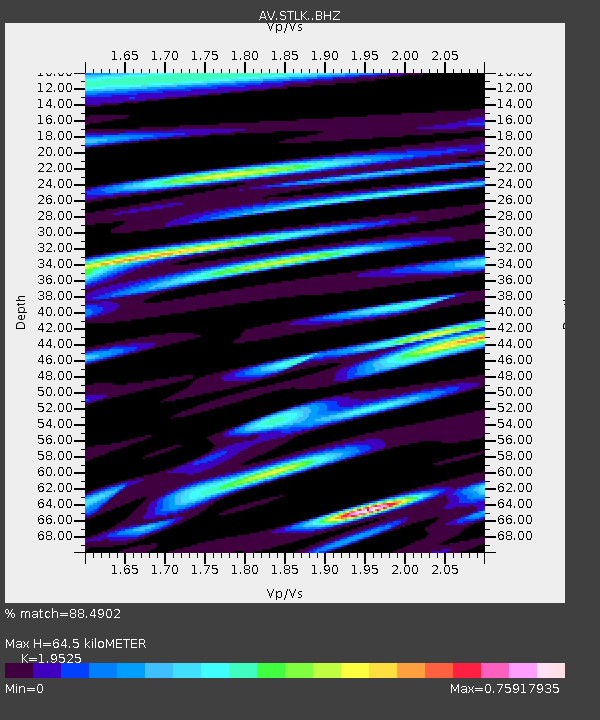
| Estimated Moho Depth: |
64.5 km |
| Estimated Crust Vp/Vs: |
1.95 |
| Assumed Crust Vp: |
6.302 km/s |
| Estimated Crust Vs: |
3.227 km/s |
| Estimated Crust Poisson's Ratio: |
0.32 |
|
| Radial Match: |
88.4902 % |
| Radial Bump: |
400 |
| Transverse Match: |
74.30815 % |
| Transverse Bump: |
400 |
| SOD ConfigId: |
25131211 |
| Insert Time: |
2021-08-13 17:17:46.647 +0000 |
| GWidth: |
2.5 |
| Max Bumps: |
400 |
| Tol: |
0.001 |
|
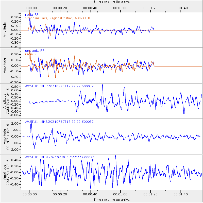
Signal To Noise
| Channel | StoN | STA | LTA |
| AV:STLK: :BHZ:20210730T17:22:22.60003Z | 41.76811 | 1.1168293E-6 | 2.6738803E-8 |
| AV:STLK: :BHN:20210730T17:22:22.60003Z | 2.6474648 | 1.4757833E-7 | 5.5743268E-8 |
| AV:STLK: :BHE:20210730T17:22:22.60003Z | 6.417405 | 3.2550844E-7 | 5.072275E-8 |
| Arrivals |
| Ps | 10.0 SECOND |
| PpPs | 30 SECOND |
| PsPs/PpSs | 40 SECOND |


