You are here: Home > Network List > C1 - Red Sismologica Nacional Stations List
> Station MT01 Daracena > Earthquake Result Viewer
MT01 Daracena - Earthquake Result Viewer
| Earthquake location: |
Peru-Ecuador Border Region |
| Earthquake latitude/longitude: |
-4.9/-80.6 |
| Earthquake time(UTC): |
2021/07/30 (211) 17:10:19 GMT |
| Earthquake Depth: |
33 km |
| Earthquake Magnitude: |
6.2 Mww |
| Earthquake Catalog/Contributor: |
NEIC PDE/us |
|
| Network: |
C1 Red Sismologica Nacional |
| Station: |
MT01 Daracena |
| Lat/Lon: |
33.86 S/71.25 W |
| Elevation: |
310 m |
|
| Distance: |
30.1 deg |
| Az: |
164.345 deg |
| Baz: |
341.149 deg |
| Ray Param: |
0.07949304 |
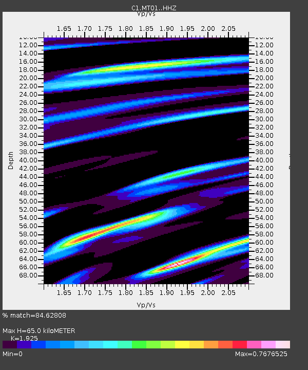
| Estimated Moho Depth: |
65.0 km |
| Estimated Crust Vp/Vs: |
1.92 |
| Assumed Crust Vp: |
6.481 km/s |
| Estimated Crust Vs: |
3.367 km/s |
| Estimated Crust Poisson's Ratio: |
0.32 |
|
| Radial Match: |
84.62808 % |
| Radial Bump: |
400 |
| Transverse Match: |
74.40149 % |
| Transverse Bump: |
400 |
| SOD ConfigId: |
25131211 |
| Insert Time: |
2021-08-13 17:19:47.581 +0000 |
| GWidth: |
2.5 |
| Max Bumps: |
400 |
| Tol: |
0.001 |
|

Signal To Noise
| Channel | StoN | STA | LTA |
| C1:MT01: :HHZ:20210730T17:15:55.269006Z | 4.5671673 | 1.194961E-6 | 2.616416E-7 |
| C1:MT01: :HHN:20210730T17:15:55.269006Z | 4.25268 | 7.557259E-7 | 1.7770581E-7 |
| C1:MT01: :HHE:20210730T17:15:55.269006Z | 0.8114314 | 1.753853E-7 | 2.1614308E-7 |
| Arrivals |
| Ps | 10 SECOND |
| PpPs | 27 SECOND |
| PsPs/PpSs | 37 SECOND |


