You are here: Home > Network List > C8 - Canadian Seismic Research Network () Stations List
> Station GRIB Gribbell Island, BC, CA > Earthquake Result Viewer
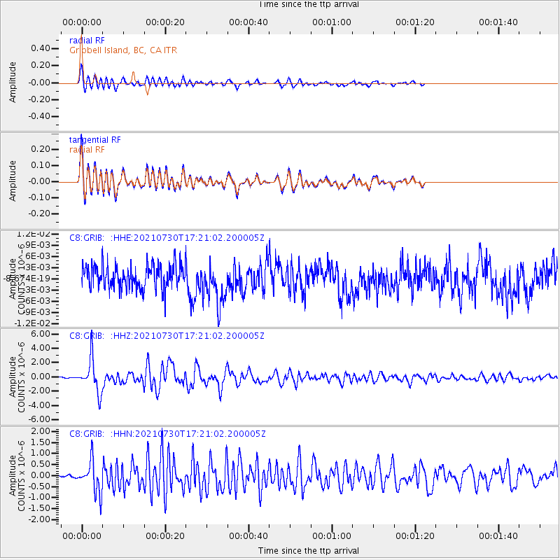
GRIB Gribbell Island, BC, CA - Earthquake Result Viewer
*The percent match for this event was below the threshold and hence no stack was calculated.
| Earthquake location: |
Peru-Ecuador Border Region |
| Earthquake latitude/longitude: |
-4.9/-80.6 |
| Earthquake time(UTC): |
2021/07/30 (211) 17:10:19 GMT |
| Earthquake Depth: |
33 km |
| Earthquake Magnitude: |
6.2 Mww |
| Earthquake Catalog/Contributor: |
NEIC PDE/us |
|
| Network: |
C8 Canadian Seismic Research Network () |
| Station: |
GRIB Gribbell Island, BC, CA |
| Lat/Lon: |
53.34 N/129.14 W |
| Elevation: |
418 m |
|
| Distance: |
70.9 deg |
| Az: |
331.604 deg |
| Baz: |
127.802 deg |
| Ray Param: |
$rayparam |
*The percent match for this event was below the threshold and hence was not used in the summary stack. |
|
| Radial Match: |
88.329025 % |
| Radial Bump: |
400 |
| Transverse Match: |
88.31601 % |
| Transverse Bump: |
400 |
| SOD ConfigId: |
25131211 |
| Insert Time: |
2021-08-13 17:20:04.620 +0000 |
| GWidth: |
2.5 |
| Max Bumps: |
400 |
| Tol: |
0.001 |
|
Signal To Noise
| Channel | StoN | STA | LTA |
| C8:GRIB: :HHZ:20210730T17:21:02.200005Z | 34.00944 | 2.333617E-6 | 6.8616735E-8 |
| C8:GRIB: :HHN:20210730T17:21:02.200005Z | 8.823341 | 7.1880294E-7 | 8.146608E-8 |
| C8:GRIB: :HHE:20210730T17:21:02.200005Z | 1.8804861 | 5.7806377E-9 | 3.0740124E-9 |
| Arrivals |
| Ps | |
| PpPs | |
| PsPs/PpSs | |


