You are here: Home > Network List > CA - Catalan Seismic Network Stations List
> Station CBRU Bruguera > Earthquake Result Viewer
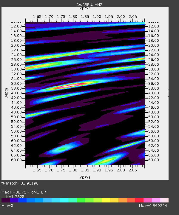
CBRU Bruguera - Earthquake Result Viewer
| Earthquake location: |
Peru-Ecuador Border Region |
| Earthquake latitude/longitude: |
-4.9/-80.6 |
| Earthquake time(UTC): |
2021/07/30 (211) 17:10:19 GMT |
| Earthquake Depth: |
33 km |
| Earthquake Magnitude: |
6.2 Mww |
| Earthquake Catalog/Contributor: |
NEIC PDE/us |
|
| Network: |
CA Catalan Seismic Network |
| Station: |
CBRU Bruguera |
| Lat/Lon: |
42.28 N/2.18 E |
| Elevation: |
1327 m |
|
| Distance: |
88.0 deg |
| Az: |
47.446 deg |
| Baz: |
261.522 deg |
| Ray Param: |
0.042904016 |
| Estimated Moho Depth: |
36.75 km |
| Estimated Crust Vp/Vs: |
1.78 |
| Assumed Crust Vp: |
6.264 km/s |
| Estimated Crust Vs: |
3.514 km/s |
| Estimated Crust Poisson's Ratio: |
0.27 |
|
| Radial Match: |
81.93196 % |
| Radial Bump: |
400 |
| Transverse Match: |
76.86685 % |
| Transverse Bump: |
400 |
| SOD ConfigId: |
25131211 |
| Insert Time: |
2021-08-13 17:20:26.748 +0000 |
| GWidth: |
2.5 |
| Max Bumps: |
400 |
| Tol: |
0.001 |
|

Signal To Noise
| Channel | StoN | STA | LTA |
| CA:CBRU: :HHZ:20210730T17:22:34.640008Z | 2.828901 | 3.6572047E-7 | 1.2928005E-7 |
| CA:CBRU: :HHN:20210730T17:22:34.640008Z | 0.68465626 | 7.907839E-8 | 1.1550087E-7 |
| CA:CBRU: :HHE:20210730T17:22:34.640008Z | 1.4480144 | 1.0786306E-7 | 7.449032E-8 |
| Arrivals |
| Ps | 4.7 SECOND |
| PpPs | 16 SECOND |
| PsPs/PpSs | 21 SECOND |


