You are here: Home > Network List > CC - Cascade Chain Volcano Monitoring Stations List
> Station KWBU Kawak Butte > Earthquake Result Viewer
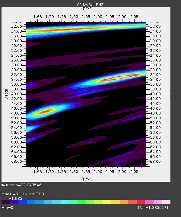
KWBU Kawak Butte - Earthquake Result Viewer
| Earthquake location: |
Peru-Ecuador Border Region |
| Earthquake latitude/longitude: |
-4.9/-80.6 |
| Earthquake time(UTC): |
2021/07/30 (211) 17:10:19 GMT |
| Earthquake Depth: |
33 km |
| Earthquake Magnitude: |
6.2 Mww |
| Earthquake Catalog/Contributor: |
NEIC PDE/us |
|
| Network: |
CC Cascade Chain Volcano Monitoring |
| Station: |
KWBU Kawak Butte |
| Lat/Lon: |
43.75 N/121.31 W |
| Elevation: |
1783 m |
|
| Distance: |
60.8 deg |
| Az: |
327.205 deg |
| Baz: |
131.866 deg |
| Ray Param: |
0.061274078 |
| Estimated Moho Depth: |
33.0 km |
| Estimated Crust Vp/Vs: |
1.99 |
| Assumed Crust Vp: |
6.597 km/s |
| Estimated Crust Vs: |
3.324 km/s |
| Estimated Crust Poisson's Ratio: |
0.33 |
|
| Radial Match: |
87.840546 % |
| Radial Bump: |
400 |
| Transverse Match: |
82.29099 % |
| Transverse Bump: |
400 |
| SOD ConfigId: |
25131211 |
| Insert Time: |
2021-08-13 17:21:03.724 +0000 |
| GWidth: |
2.5 |
| Max Bumps: |
400 |
| Tol: |
0.001 |
|

Signal To Noise
| Channel | StoN | STA | LTA |
| CC:KWBU: :BHZ:20210730T17:19:57.129998Z | 57.638695 | 4.181958E-6 | 7.255469E-8 |
| CC:KWBU: :BHN:20210730T17:19:57.129998Z | 18.51757 | 1.583324E-6 | 8.550387E-8 |
| CC:KWBU: :BHE:20210730T17:19:57.129998Z | 9.93316 | 8.690522E-7 | 8.749001E-8 |
| Arrivals |
| Ps | 5.1 SECOND |
| PpPs | 14 SECOND |
| PsPs/PpSs | 19 SECOND |


