You are here: Home > Network List > CC - Cascade Chain Volcano Monitoring Stations List
> Station PR01 Puyallup River 01 > Earthquake Result Viewer
PR01 Puyallup River 01 - Earthquake Result Viewer
| Earthquake location: |
Peru-Ecuador Border Region |
| Earthquake latitude/longitude: |
-4.9/-80.6 |
| Earthquake time(UTC): |
2021/07/30 (211) 17:10:19 GMT |
| Earthquake Depth: |
33 km |
| Earthquake Magnitude: |
6.2 Mww |
| Earthquake Catalog/Contributor: |
NEIC PDE/us |
|
| Network: |
CC Cascade Chain Volcano Monitoring |
| Station: |
PR01 Puyallup River 01 |
| Lat/Lon: |
46.91 N/122.04 W |
| Elevation: |
648 m |
|
| Distance: |
63.3 deg |
| Az: |
329.468 deg |
| Baz: |
132.414 deg |
| Ray Param: |
0.05964378 |
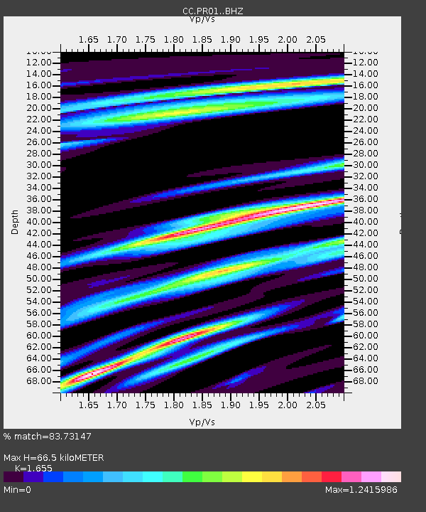
| Estimated Moho Depth: |
66.5 km |
| Estimated Crust Vp/Vs: |
1.65 |
| Assumed Crust Vp: |
6.566 km/s |
| Estimated Crust Vs: |
3.967 km/s |
| Estimated Crust Poisson's Ratio: |
0.21 |
|
| Radial Match: |
83.73147 % |
| Radial Bump: |
400 |
| Transverse Match: |
76.84321 % |
| Transverse Bump: |
400 |
| SOD ConfigId: |
25131211 |
| Insert Time: |
2021-08-13 17:21:12.152 +0000 |
| GWidth: |
2.5 |
| Max Bumps: |
400 |
| Tol: |
0.001 |
|

Signal To Noise
| Channel | StoN | STA | LTA |
| CC:PR01: :BHZ:20210730T17:20:13.859979Z | 20.268183 | 2.1296182E-6 | 1.0507198E-7 |
| CC:PR01: :BHN:20210730T17:20:13.859979Z | 5.749549 | 5.164029E-7 | 8.9816254E-8 |
| CC:PR01: :BHE:20210730T17:20:13.859979Z | 2.479878 | 4.3517014E-7 | 1.7548047E-7 |
| Arrivals |
| Ps | 7.0 SECOND |
| PpPs | 26 SECOND |
| PsPs/PpSs | 33 SECOND |


