You are here: Home > Network List > CI - Caltech Regional Seismic Network Stations List
> Station GRA Grapevine Ranger Station, Death Valley, CA, USA > Earthquake Result Viewer
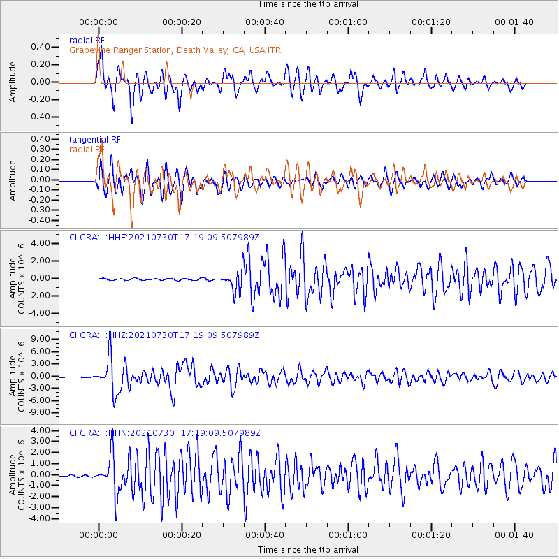
GRA Grapevine Ranger Station, Death Valley, CA, USA - Earthquake Result Viewer
*The percent match for this event was below the threshold and hence no stack was calculated.
| Earthquake location: |
Peru-Ecuador Border Region |
| Earthquake latitude/longitude: |
-4.9/-80.6 |
| Earthquake time(UTC): |
2021/07/30 (211) 17:10:19 GMT |
| Earthquake Depth: |
33 km |
| Earthquake Magnitude: |
6.2 Mww |
| Earthquake Catalog/Contributor: |
NEIC PDE/us |
|
| Network: |
CI Caltech Regional Seismic Network |
| Station: |
GRA Grapevine Ranger Station, Death Valley, CA, USA |
| Lat/Lon: |
37.00 N/117.37 W |
| Elevation: |
689 m |
|
| Distance: |
54.0 deg |
| Az: |
323.678 deg |
| Baz: |
132.512 deg |
| Ray Param: |
$rayparam |
*The percent match for this event was below the threshold and hence was not used in the summary stack. |
|
| Radial Match: |
84.50272 % |
| Radial Bump: |
400 |
| Transverse Match: |
75.60406 % |
| Transverse Bump: |
400 |
| SOD ConfigId: |
25131211 |
| Insert Time: |
2021-08-13 17:22:40.116 +0000 |
| GWidth: |
2.5 |
| Max Bumps: |
400 |
| Tol: |
0.001 |
|
Signal To Noise
| Channel | StoN | STA | LTA |
| CI:GRA: :HHZ:20210730T17:19:09.507989Z | 55.372894 | 4.5490156E-6 | 8.215239E-8 |
| CI:GRA: :HHN:20210730T17:19:09.507989Z | 34.81423 | 1.8103619E-6 | 5.2000626E-8 |
| CI:GRA: :HHE:20210730T17:19:09.507989Z | 12.316148 | 1.221722E-6 | 9.9196754E-8 |
| Arrivals |
| Ps | |
| PpPs | |
| PsPs/PpSs | |


