You are here: Home > Network List > CN - Canadian National Seismograph Network Stations List
> Station LLLB Lillooet, BC, CA > Earthquake Result Viewer
LLLB Lillooet, BC, CA - Earthquake Result Viewer
| Earthquake location: |
Peru-Ecuador Border Region |
| Earthquake latitude/longitude: |
-4.9/-80.6 |
| Earthquake time(UTC): |
2021/07/30 (211) 17:10:19 GMT |
| Earthquake Depth: |
33 km |
| Earthquake Magnitude: |
6.2 Mww |
| Earthquake Catalog/Contributor: |
NEIC PDE/us |
|
| Network: |
CN Canadian National Seismograph Network |
| Station: |
LLLB Lillooet, BC, CA |
| Lat/Lon: |
50.61 N/121.88 W |
| Elevation: |
700 m |
|
| Distance: |
65.7 deg |
| Az: |
332.539 deg |
| Baz: |
133.854 deg |
| Ray Param: |
0.058027733 |
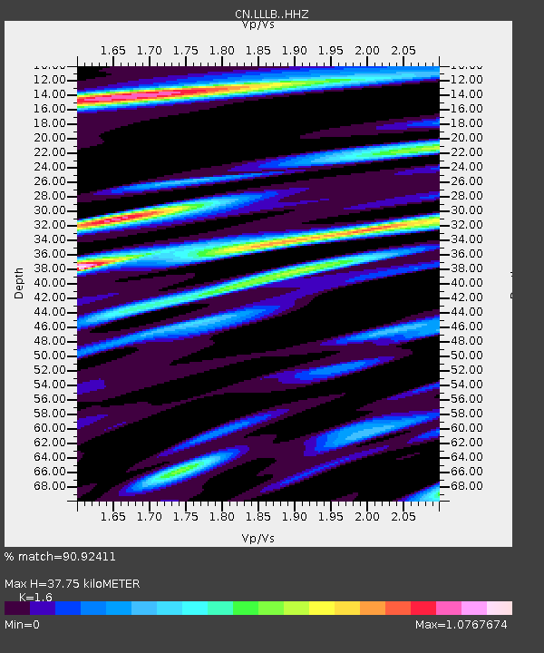
| Estimated Moho Depth: |
37.75 km |
| Estimated Crust Vp/Vs: |
1.60 |
| Assumed Crust Vp: |
6.597 km/s |
| Estimated Crust Vs: |
4.123 km/s |
| Estimated Crust Poisson's Ratio: |
0.18 |
|
| Radial Match: |
90.92411 % |
| Radial Bump: |
400 |
| Transverse Match: |
74.65874 % |
| Transverse Bump: |
400 |
| SOD ConfigId: |
25131211 |
| Insert Time: |
2021-08-13 17:25:12.004 +0000 |
| GWidth: |
2.5 |
| Max Bumps: |
400 |
| Tol: |
0.001 |
|
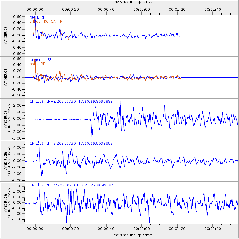
Signal To Noise
| Channel | StoN | STA | LTA |
| CN:LLLB: :HHZ:20210730T17:20:29.869988Z | 42.839897 | 2.726488E-6 | 6.364366E-8 |
| CN:LLLB: :HHN:20210730T17:20:29.869988Z | 16.444683 | 7.812771E-7 | 4.7509403E-8 |
| CN:LLLB: :HHE:20210730T17:20:29.869988Z | 25.31211 | 1.0295959E-6 | 4.0676017E-8 |
| Arrivals |
| Ps | 3.6 SECOND |
| PpPs | 14 SECOND |
| PsPs/PpSs | 18 SECOND |


