You are here: Home > Network List > CN - Canadian National Seismograph Network Stations List
> Station TBO Thunder Bay, ON, CA > Earthquake Result Viewer
TBO Thunder Bay, ON, CA - Earthquake Result Viewer
| Earthquake location: |
Peru-Ecuador Border Region |
| Earthquake latitude/longitude: |
-4.9/-80.6 |
| Earthquake time(UTC): |
2021/07/30 (211) 17:10:19 GMT |
| Earthquake Depth: |
33 km |
| Earthquake Magnitude: |
6.2 Mww |
| Earthquake Catalog/Contributor: |
NEIC PDE/us |
|
| Network: |
CN Canadian National Seismograph Network |
| Station: |
TBO Thunder Bay, ON, CA |
| Lat/Lon: |
48.65 N/89.41 W |
| Elevation: |
475 m |
|
| Distance: |
53.9 deg |
| Az: |
352.782 deg |
| Baz: |
169.12 deg |
| Ray Param: |
0.06572189 |
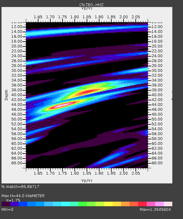
| Estimated Moho Depth: |
44.0 km |
| Estimated Crust Vp/Vs: |
1.75 |
| Assumed Crust Vp: |
6.467 km/s |
| Estimated Crust Vs: |
3.695 km/s |
| Estimated Crust Poisson's Ratio: |
0.26 |
|
| Radial Match: |
95.96717 % |
| Radial Bump: |
306 |
| Transverse Match: |
80.73398 % |
| Transverse Bump: |
400 |
| SOD ConfigId: |
25131211 |
| Insert Time: |
2021-08-13 17:26:07.335 +0000 |
| GWidth: |
2.5 |
| Max Bumps: |
400 |
| Tol: |
0.001 |
|

Signal To Noise
| Channel | StoN | STA | LTA |
| CN:TBO: :HHZ:20210730T17:19:08.890008Z | 25.406591 | 3.2315297E-6 | 1.2719256E-7 |
| CN:TBO: :HHN:20210730T17:19:08.890008Z | 18.54155 | 1.5624092E-6 | 8.42653E-8 |
| CN:TBO: :HHE:20210730T17:19:08.890008Z | 5.0925665 | 5.654373E-7 | 1.1103189E-7 |
| Arrivals |
| Ps | 5.4 SECOND |
| PpPs | 18 SECOND |
| PsPs/PpSs | 23 SECOND |


