You are here: Home > Network List > GM - US Geological Survey Networks Stations List
> Station NMP41 New Mexico Permian - Site# W4S1 > Earthquake Result Viewer
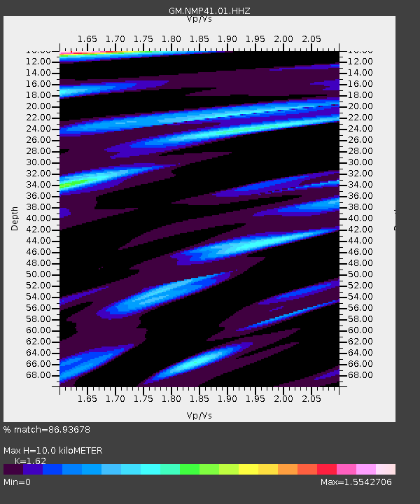
NMP41 New Mexico Permian - Site# W4S1 - Earthquake Result Viewer
| Earthquake location: |
Peru-Ecuador Border Region |
| Earthquake latitude/longitude: |
-4.9/-80.6 |
| Earthquake time(UTC): |
2021/07/30 (211) 17:10:19 GMT |
| Earthquake Depth: |
33 km |
| Earthquake Magnitude: |
6.2 Mww |
| Earthquake Catalog/Contributor: |
NEIC PDE/us |
|
| Network: |
GM US Geological Survey Networks |
| Station: |
NMP41 New Mexico Permian - Site# W4S1 |
| Lat/Lon: |
32.01 N/103.60 W |
| Elevation: |
960 m |
|
| Distance: |
42.8 deg |
| Az: |
330.738 deg |
| Baz: |
145.024 deg |
| Ray Param: |
0.07291824 |
| Estimated Moho Depth: |
10.0 km |
| Estimated Crust Vp/Vs: |
1.62 |
| Assumed Crust Vp: |
6.129 km/s |
| Estimated Crust Vs: |
3.783 km/s |
| Estimated Crust Poisson's Ratio: |
0.19 |
|
| Radial Match: |
86.93678 % |
| Radial Bump: |
400 |
| Transverse Match: |
66.194695 % |
| Transverse Bump: |
400 |
| SOD ConfigId: |
25131211 |
| Insert Time: |
2021-08-13 17:28:19.560 +0000 |
| GWidth: |
2.5 |
| Max Bumps: |
400 |
| Tol: |
0.001 |
|

Signal To Noise
| Channel | StoN | STA | LTA |
| GM:NMP41:01:HHZ:20210730T17:17:43.119988Z | 39.847004 | 3.5555315E-6 | 8.922958E-8 |
| GM:NMP41:01:HHN:20210730T17:17:43.119988Z | 17.940279 | 1.4751218E-6 | 8.222403E-8 |
| GM:NMP41:01:HHE:20210730T17:17:43.119988Z | 11.560745 | 1.1674402E-6 | 1.0098313E-7 |
| Arrivals |
| Ps | 1.1 SECOND |
| PpPs | 4.0 SECOND |
| PsPs/PpSs | 5.1 SECOND |


