You are here: Home > Network List > IM - International Miscellaneous Stations Stations List
> Station TKL Tuckaleechee Caverns, TN, USA > Earthquake Result Viewer
TKL Tuckaleechee Caverns, TN, USA - Earthquake Result Viewer
| Earthquake location: |
Peru-Ecuador Border Region |
| Earthquake latitude/longitude: |
-4.9/-80.6 |
| Earthquake time(UTC): |
2021/07/30 (211) 17:10:19 GMT |
| Earthquake Depth: |
33 km |
| Earthquake Magnitude: |
6.2 Mww |
| Earthquake Catalog/Contributor: |
NEIC PDE/us |
|
| Network: |
IM International Miscellaneous Stations |
| Station: |
TKL Tuckaleechee Caverns, TN, USA |
| Lat/Lon: |
35.66 N/83.77 W |
| Elevation: |
351 m |
|
| Distance: |
40.5 deg |
| Az: |
356.021 deg |
| Baz: |
175.13 deg |
| Ray Param: |
0.074311525 |
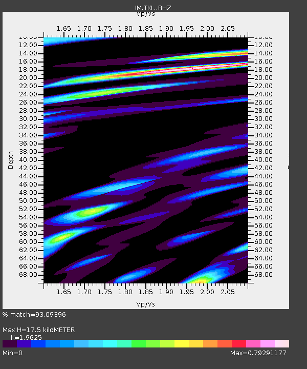
| Estimated Moho Depth: |
17.5 km |
| Estimated Crust Vp/Vs: |
1.96 |
| Assumed Crust Vp: |
6.35 km/s |
| Estimated Crust Vs: |
3.236 km/s |
| Estimated Crust Poisson's Ratio: |
0.32 |
|
| Radial Match: |
93.09396 % |
| Radial Bump: |
367 |
| Transverse Match: |
85.05651 % |
| Transverse Bump: |
400 |
| SOD ConfigId: |
25131211 |
| Insert Time: |
2021-08-13 17:29:53.128 +0000 |
| GWidth: |
2.5 |
| Max Bumps: |
400 |
| Tol: |
0.001 |
|

Signal To Noise
| Channel | StoN | STA | LTA |
| IM:TKL: :BHZ:20210730T17:17:24.519006Z | 41.764267 | 3.5626272E-6 | 8.5303235E-8 |
| IM:TKL: :BHN:20210730T17:17:24.519006Z | 18.175285 | 1.788386E-6 | 9.839659E-8 |
| IM:TKL: :BHE:20210730T17:17:24.519006Z | 5.961755 | 5.599629E-7 | 9.3925856E-8 |
| Arrivals |
| Ps | 2.8 SECOND |
| PpPs | 7.7 SECOND |
| PsPs/PpSs | 10 SECOND |


