You are here: Home > Network List > LD - Lamont-Doherty Cooperative Seismographic Network Stations List
> Station FLET Fletcher, VT > Earthquake Result Viewer
FLET Fletcher, VT - Earthquake Result Viewer
| Earthquake location: |
Peru-Ecuador Border Region |
| Earthquake latitude/longitude: |
-4.9/-80.6 |
| Earthquake time(UTC): |
2021/07/30 (211) 17:10:19 GMT |
| Earthquake Depth: |
33 km |
| Earthquake Magnitude: |
6.2 Mww |
| Earthquake Catalog/Contributor: |
NEIC PDE/us |
|
| Network: |
LD Lamont-Doherty Cooperative Seismographic Network |
| Station: |
FLET Fletcher, VT |
| Lat/Lon: |
44.72 N/72.95 W |
| Elevation: |
366 m |
|
| Distance: |
49.9 deg |
| Az: |
7.127 deg |
| Baz: |
189.985 deg |
| Ray Param: |
0.068348035 |
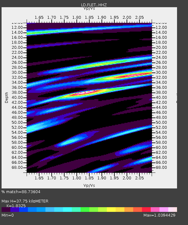
| Estimated Moho Depth: |
37.75 km |
| Estimated Crust Vp/Vs: |
1.83 |
| Assumed Crust Vp: |
6.419 km/s |
| Estimated Crust Vs: |
3.503 km/s |
| Estimated Crust Poisson's Ratio: |
0.29 |
|
| Radial Match: |
88.73604 % |
| Radial Bump: |
283 |
| Transverse Match: |
75.60116 % |
| Transverse Bump: |
400 |
| SOD ConfigId: |
25131211 |
| Insert Time: |
2021-08-13 17:30:36.912 +0000 |
| GWidth: |
2.5 |
| Max Bumps: |
400 |
| Tol: |
0.001 |
|

Signal To Noise
| Channel | StoN | STA | LTA |
| LD:FLET: :HHZ:20210730T17:18:39.115014Z | 10.031071 | 2.3107266E-6 | 2.3035693E-7 |
| LD:FLET: :HHN:20210730T17:18:39.115014Z | 9.036877 | 1.0734741E-6 | 1.1878817E-7 |
| LD:FLET: :HHE:20210730T17:18:39.115014Z | 3.0365098 | 5.29366E-7 | 1.743337E-7 |
| Arrivals |
| Ps | 5.2 SECOND |
| PpPs | 16 SECOND |
| PsPs/PpSs | 21 SECOND |


