You are here: Home > Network List > LD - Lamont-Doherty Cooperative Seismographic Network Stations List
> Station WUPA West Chester University of Pennsylvania > Earthquake Result Viewer
WUPA West Chester University of Pennsylvania - Earthquake Result Viewer
| Earthquake location: |
Peru-Ecuador Border Region |
| Earthquake latitude/longitude: |
-4.9/-80.6 |
| Earthquake time(UTC): |
2021/07/30 (211) 17:10:19 GMT |
| Earthquake Depth: |
33 km |
| Earthquake Magnitude: |
6.2 Mww |
| Earthquake Catalog/Contributor: |
NEIC PDE/us |
|
| Network: |
LD Lamont-Doherty Cooperative Seismographic Network |
| Station: |
WUPA West Chester University of Pennsylvania |
| Lat/Lon: |
39.93 N/75.61 W |
| Elevation: |
86 m |
|
| Distance: |
44.9 deg |
| Az: |
5.446 deg |
| Baz: |
187.064 deg |
| Ray Param: |
0.07158265 |
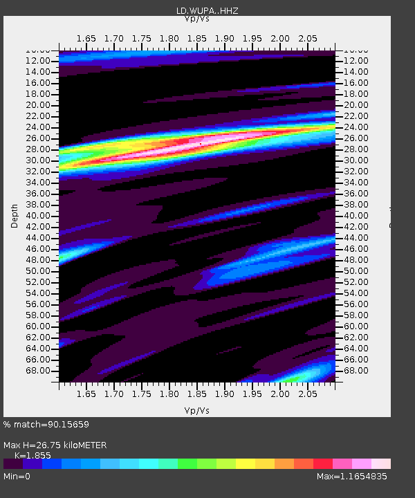
| Estimated Moho Depth: |
26.75 km |
| Estimated Crust Vp/Vs: |
1.86 |
| Assumed Crust Vp: |
6.287 km/s |
| Estimated Crust Vs: |
3.389 km/s |
| Estimated Crust Poisson's Ratio: |
0.30 |
|
| Radial Match: |
90.15659 % |
| Radial Bump: |
254 |
| Transverse Match: |
69.8862 % |
| Transverse Bump: |
394 |
| SOD ConfigId: |
25131211 |
| Insert Time: |
2021-08-13 17:31:02.041 +0000 |
| GWidth: |
2.5 |
| Max Bumps: |
400 |
| Tol: |
0.001 |
|
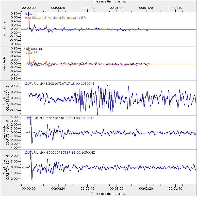
Signal To Noise
| Channel | StoN | STA | LTA |
| LD:WUPA: :HHZ:20210730T17:18:00.105004Z | 18.748459 | 1.5372798E-6 | 8.1995E-8 |
| LD:WUPA: :HHN:20210730T17:18:00.105004Z | 18.197145 | 1.060926E-6 | 5.8301783E-8 |
| LD:WUPA: :HHE:20210730T17:18:00.105004Z | 1.2184567 | 1.1746656E-7 | 9.640602E-8 |
| Arrivals |
| Ps | 3.9 SECOND |
| PpPs | 11 SECOND |
| PsPs/PpSs | 15 SECOND |


