You are here: Home > Network List > MG - Seismic Network of the NorthEastern Mexico Stations List
> Station TXMV CEIEPAA, FMVZ, UNAM, Tequisquiapan, Queretaro, MEXICO > Earthquake Result Viewer
TXMV CEIEPAA, FMVZ, UNAM, Tequisquiapan, Queretaro, MEXICO - Earthquake Result Viewer
| Earthquake location: |
Peru-Ecuador Border Region |
| Earthquake latitude/longitude: |
-4.9/-80.6 |
| Earthquake time(UTC): |
2021/07/30 (211) 17:10:19 GMT |
| Earthquake Depth: |
33 km |
| Earthquake Magnitude: |
6.2 Mww |
| Earthquake Catalog/Contributor: |
NEIC PDE/us |
|
| Network: |
MG Seismic Network of the NorthEastern Mexico |
| Station: |
TXMV CEIEPAA, FMVZ, UNAM, Tequisquiapan, Queretaro, MEXICO |
| Lat/Lon: |
20.61 N/99.93 W |
| Elevation: |
1908 m |
|
| Distance: |
31.7 deg |
| Az: |
323.837 deg |
| Baz: |
141.125 deg |
| Ray Param: |
0.078930415 |
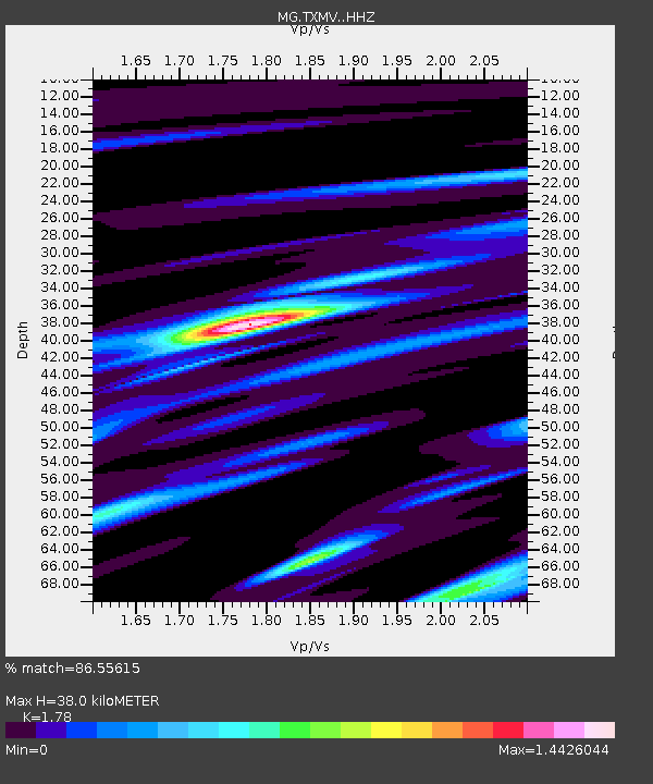
| Estimated Moho Depth: |
38.0 km |
| Estimated Crust Vp/Vs: |
1.78 |
| Assumed Crust Vp: |
6.466 km/s |
| Estimated Crust Vs: |
3.633 km/s |
| Estimated Crust Poisson's Ratio: |
0.27 |
|
| Radial Match: |
86.55615 % |
| Radial Bump: |
331 |
| Transverse Match: |
65.97804 % |
| Transverse Bump: |
400 |
| SOD ConfigId: |
25131211 |
| Insert Time: |
2021-08-13 17:31:18.727 +0000 |
| GWidth: |
2.5 |
| Max Bumps: |
400 |
| Tol: |
0.001 |
|

Signal To Noise
| Channel | StoN | STA | LTA |
| MG:TXMV: :HHZ:20210730T17:16:09.589013Z | 19.927649 | 1.2474292E-6 | 6.259791E-8 |
| MG:TXMV: :HHN:20210730T17:16:09.589013Z | 12.37656 | 5.077781E-7 | 4.1027402E-8 |
| MG:TXMV: :HHE:20210730T17:16:09.589013Z | 6.056577 | 3.9449398E-7 | 6.513481E-8 |
| Arrivals |
| Ps | 5.0 SECOND |
| PpPs | 15 SECOND |
| PsPs/PpSs | 20 SECOND |


