You are here: Home > Network List > N4 - Central and EAstern US Network Stations List
> Station 060A Indiantown, FL, USA > Earthquake Result Viewer
060A Indiantown, FL, USA - Earthquake Result Viewer
| Earthquake location: |
Peru-Ecuador Border Region |
| Earthquake latitude/longitude: |
-4.9/-80.6 |
| Earthquake time(UTC): |
2021/07/30 (211) 17:10:19 GMT |
| Earthquake Depth: |
33 km |
| Earthquake Magnitude: |
6.2 Mww |
| Earthquake Catalog/Contributor: |
NEIC PDE/us |
|
| Network: |
N4 Central and EAstern US Network |
| Station: |
060A Indiantown, FL, USA |
| Lat/Lon: |
27.04 N/80.36 W |
| Elevation: |
9.0 m |
|
| Distance: |
31.8 deg |
| Az: |
0.407 deg |
| Baz: |
180.455 deg |
| Ray Param: |
0.07889585 |
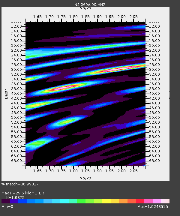
| Estimated Moho Depth: |
29.5 km |
| Estimated Crust Vp/Vs: |
1.99 |
| Assumed Crust Vp: |
6.347 km/s |
| Estimated Crust Vs: |
3.193 km/s |
| Estimated Crust Poisson's Ratio: |
0.33 |
|
| Radial Match: |
86.99327 % |
| Radial Bump: |
400 |
| Transverse Match: |
59.990215 % |
| Transverse Bump: |
400 |
| SOD ConfigId: |
25131211 |
| Insert Time: |
2021-08-13 17:31:29.743 +0000 |
| GWidth: |
2.5 |
| Max Bumps: |
400 |
| Tol: |
0.001 |
|

Signal To Noise
| Channel | StoN | STA | LTA |
| N4:060A:00:HHZ:20210730T17:16:10.33001Z | 11.895628 | 3.9247243E-6 | 3.2992997E-7 |
| N4:060A:00:HH1:20210730T17:16:10.33001Z | 7.424253 | 3.8844864E-6 | 5.2321576E-7 |
| N4:060A:00:HH2:20210730T17:16:10.33001Z | 3.129356 | 1.3442349E-6 | 4.295564E-7 |
| Arrivals |
| Ps | 4.9 SECOND |
| PpPs | 13 SECOND |
| PsPs/PpSs | 18 SECOND |


