You are here: Home > Network List > N4 - Central and EAstern US Network Stations List
> Station 656A Willston, FL, USA > Earthquake Result Viewer
656A Willston, FL, USA - Earthquake Result Viewer
| Earthquake location: |
Peru-Ecuador Border Region |
| Earthquake latitude/longitude: |
-4.9/-80.6 |
| Earthquake time(UTC): |
2021/07/30 (211) 17:10:19 GMT |
| Earthquake Depth: |
33 km |
| Earthquake Magnitude: |
6.2 Mww |
| Earthquake Catalog/Contributor: |
NEIC PDE/us |
|
| Network: |
N4 Central and EAstern US Network |
| Station: |
656A Willston, FL, USA |
| Lat/Lon: |
29.37 N/82.53 W |
| Elevation: |
28 m |
|
| Distance: |
34.2 deg |
| Az: |
356.995 deg |
| Baz: |
176.569 deg |
| Ray Param: |
0.07782753 |
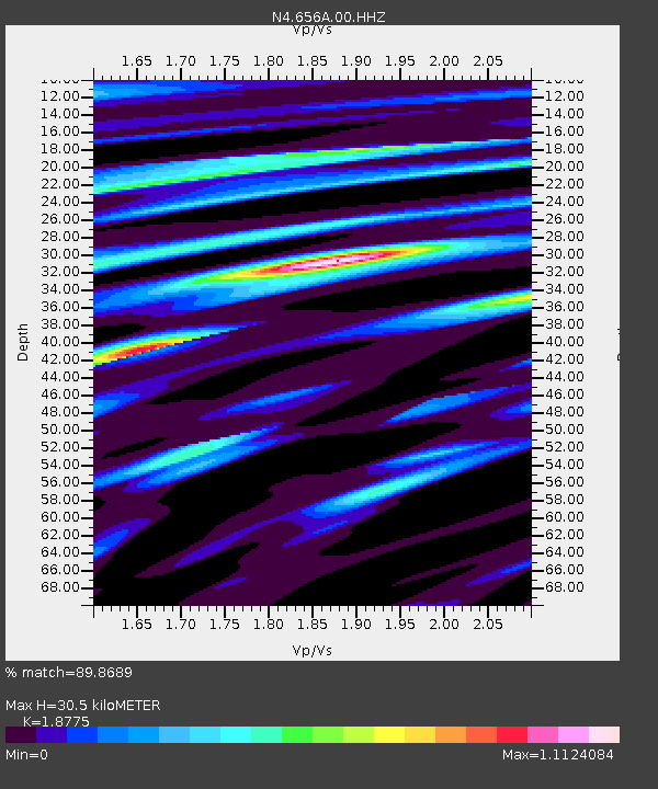
| Estimated Moho Depth: |
30.5 km |
| Estimated Crust Vp/Vs: |
1.88 |
| Assumed Crust Vp: |
5.989 km/s |
| Estimated Crust Vs: |
3.19 km/s |
| Estimated Crust Poisson's Ratio: |
0.30 |
|
| Radial Match: |
89.8689 % |
| Radial Bump: |
335 |
| Transverse Match: |
60.49031 % |
| Transverse Bump: |
400 |
| SOD ConfigId: |
25131211 |
| Insert Time: |
2021-08-13 17:31:44.180 +0000 |
| GWidth: |
2.5 |
| Max Bumps: |
400 |
| Tol: |
0.001 |
|

Signal To Noise
| Channel | StoN | STA | LTA |
| N4:656A:00:HHZ:20210730T17:16:30.990014Z | 27.41571 | 3.3602396E-6 | 1.225662E-7 |
| N4:656A:00:HH1:20210730T17:16:30.990014Z | 13.695604 | 1.6282603E-6 | 1.1888926E-7 |
| N4:656A:00:HH2:20210730T17:16:30.990014Z | 2.499101 | 2.9820427E-7 | 1.1932462E-7 |
| Arrivals |
| Ps | 4.8 SECOND |
| PpPs | 14 SECOND |
| PsPs/PpSs | 19 SECOND |


