You are here: Home > Network List > N4 - Central and EAstern US Network Stations List
> Station I40B Norwalk, WI, USA > Earthquake Result Viewer
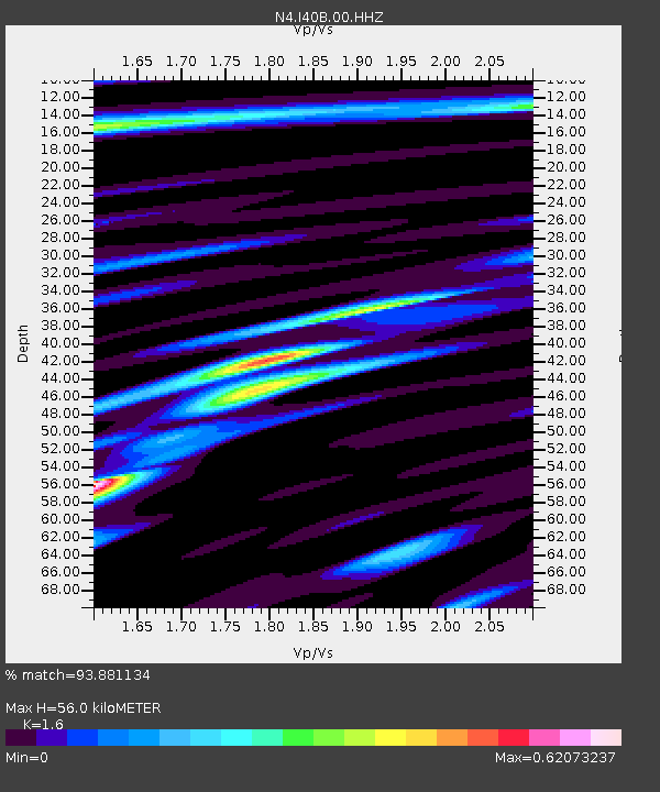
I40B Norwalk, WI, USA - Earthquake Result Viewer
| Earthquake location: |
Peru-Ecuador Border Region |
| Earthquake latitude/longitude: |
-4.9/-80.6 |
| Earthquake time(UTC): |
2021/07/30 (211) 17:10:19 GMT |
| Earthquake Depth: |
33 km |
| Earthquake Magnitude: |
6.2 Mww |
| Earthquake Catalog/Contributor: |
NEIC PDE/us |
|
| Network: |
N4 Central and EAstern US Network |
| Station: |
I40B Norwalk, WI, USA |
| Lat/Lon: |
43.89 N/90.62 W |
| Elevation: |
419 m |
|
| Distance: |
49.4 deg |
| Az: |
350.473 deg |
| Baz: |
166.815 deg |
| Ray Param: |
0.06865933 |
| Estimated Moho Depth: |
56.0 km |
| Estimated Crust Vp/Vs: |
1.60 |
| Assumed Crust Vp: |
6.53 km/s |
| Estimated Crust Vs: |
4.082 km/s |
| Estimated Crust Poisson's Ratio: |
0.18 |
|
| Radial Match: |
93.881134 % |
| Radial Bump: |
379 |
| Transverse Match: |
80.72188 % |
| Transverse Bump: |
400 |
| SOD ConfigId: |
25131211 |
| Insert Time: |
2021-08-13 17:32:03.655 +0000 |
| GWidth: |
2.5 |
| Max Bumps: |
400 |
| Tol: |
0.001 |
|

Signal To Noise
| Channel | StoN | STA | LTA |
| N4:I40B:00:HHZ:20210730T17:18:35.528008Z | 17.91983 | 2.6567725E-6 | 1.482588E-7 |
| N4:I40B:00:HH1:20210730T17:18:35.528008Z | 14.315795 | 7.1762105E-7 | 5.0127923E-8 |
| N4:I40B:00:HH2:20210730T17:18:35.528008Z | 3.691159 | 4.163251E-7 | 1.127898E-7 |
| Arrivals |
| Ps | 5.5 SECOND |
| PpPs | 21 SECOND |
| PsPs/PpSs | 26 SECOND |


