You are here: Home > Network List > N4 - Central and EAstern US Network Stations List
> Station L59A Walton, NY, USA > Earthquake Result Viewer
L59A Walton, NY, USA - Earthquake Result Viewer
| Earthquake location: |
Peru-Ecuador Border Region |
| Earthquake latitude/longitude: |
-4.9/-80.6 |
| Earthquake time(UTC): |
2021/07/30 (211) 17:10:19 GMT |
| Earthquake Depth: |
33 km |
| Earthquake Magnitude: |
6.2 Mww |
| Earthquake Catalog/Contributor: |
NEIC PDE/us |
|
| Network: |
N4 Central and EAstern US Network |
| Station: |
L59A Walton, NY, USA |
| Lat/Lon: |
42.19 N/75.04 W |
| Elevation: |
677 m |
|
| Distance: |
47.2 deg |
| Az: |
5.634 deg |
| Baz: |
187.563 deg |
| Ray Param: |
0.070105776 |
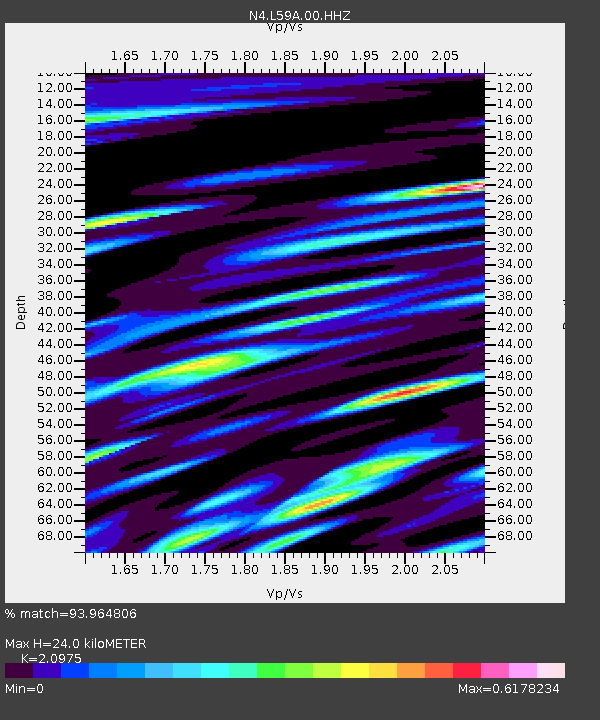
| Estimated Moho Depth: |
24.0 km |
| Estimated Crust Vp/Vs: |
2.10 |
| Assumed Crust Vp: |
6.419 km/s |
| Estimated Crust Vs: |
3.06 km/s |
| Estimated Crust Poisson's Ratio: |
0.35 |
|
| Radial Match: |
93.964806 % |
| Radial Bump: |
394 |
| Transverse Match: |
88.41385 % |
| Transverse Bump: |
400 |
| SOD ConfigId: |
25131211 |
| Insert Time: |
2021-08-13 17:32:30.224 +0000 |
| GWidth: |
2.5 |
| Max Bumps: |
400 |
| Tol: |
0.001 |
|

Signal To Noise
| Channel | StoN | STA | LTA |
| N4:L59A:00:HHZ:20210730T17:18:18.119012Z | 19.240685 | 4.402957E-6 | 2.2883577E-7 |
| N4:L59A:00:HH1:20210730T17:18:18.119012Z | 11.920649 | 2.2766908E-6 | 1.9098715E-7 |
| N4:L59A:00:HH2:20210730T17:18:18.119012Z | 3.8920622 | 6.599096E-7 | 1.6955268E-7 |
| Arrivals |
| Ps | 4.3 SECOND |
| PpPs | 11 SECOND |
| PsPs/PpSs | 15 SECOND |


