You are here: Home > Network List > N4 - Central and EAstern US Network Stations List
> Station M63A Gales Ferry, CT, USA > Earthquake Result Viewer
M63A Gales Ferry, CT, USA - Earthquake Result Viewer
| Earthquake location: |
Peru-Ecuador Border Region |
| Earthquake latitude/longitude: |
-4.9/-80.6 |
| Earthquake time(UTC): |
2021/07/30 (211) 17:10:19 GMT |
| Earthquake Depth: |
33 km |
| Earthquake Magnitude: |
6.2 Mww |
| Earthquake Catalog/Contributor: |
NEIC PDE/us |
|
| Network: |
N4 Central and EAstern US Network |
| Station: |
M63A Gales Ferry, CT, USA |
| Lat/Lon: |
41.40 N/72.05 W |
| Elevation: |
44 m |
|
| Distance: |
46.8 deg |
| Az: |
8.835 deg |
| Baz: |
191.738 deg |
| Ray Param: |
0.07037271 |
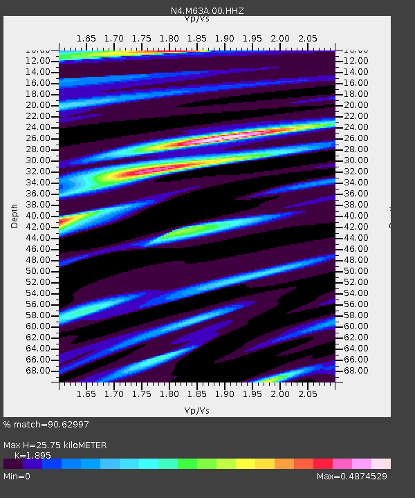
| Estimated Moho Depth: |
25.75 km |
| Estimated Crust Vp/Vs: |
1.89 |
| Assumed Crust Vp: |
6.472 km/s |
| Estimated Crust Vs: |
3.415 km/s |
| Estimated Crust Poisson's Ratio: |
0.31 |
|
| Radial Match: |
90.62997 % |
| Radial Bump: |
235 |
| Transverse Match: |
65.403404 % |
| Transverse Bump: |
400 |
| SOD ConfigId: |
25131211 |
| Insert Time: |
2021-08-13 17:32:38.237 +0000 |
| GWidth: |
2.5 |
| Max Bumps: |
400 |
| Tol: |
0.001 |
|

Signal To Noise
| Channel | StoN | STA | LTA |
| N4:M63A:00:HHZ:20210730T17:18:15.010003Z | 15.024027 | 3.52992E-6 | 2.3495164E-7 |
| N4:M63A:00:HH1:20210730T17:18:15.010003Z | 8.481386 | 1.6371989E-6 | 1.9303435E-7 |
| N4:M63A:00:HH2:20210730T17:18:15.010003Z | 2.6351037 | 4.6816277E-7 | 1.7766389E-7 |
| Arrivals |
| Ps | 3.8 SECOND |
| PpPs | 11 SECOND |
| PsPs/PpSs | 15 SECOND |


