You are here: Home > Network List > N4 - Central and EAstern US Network Stations List
> Station N58A Sunbury, PA, USA > Earthquake Result Viewer
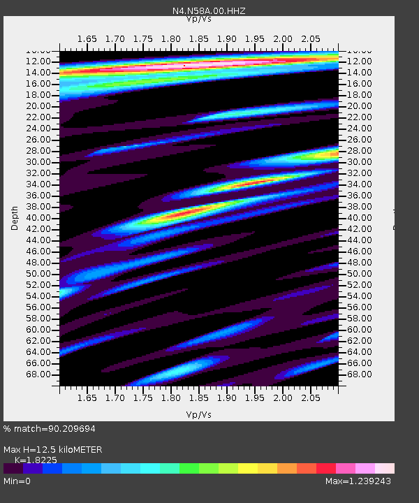
N58A Sunbury, PA, USA - Earthquake Result Viewer
| Earthquake location: |
Peru-Ecuador Border Region |
| Earthquake latitude/longitude: |
-4.9/-80.6 |
| Earthquake time(UTC): |
2021/07/30 (211) 17:10:19 GMT |
| Earthquake Depth: |
33 km |
| Earthquake Magnitude: |
6.2 Mww |
| Earthquake Catalog/Contributor: |
NEIC PDE/us |
|
| Network: |
N4 Central and EAstern US Network |
| Station: |
N58A Sunbury, PA, USA |
| Lat/Lon: |
40.84 N/76.72 W |
| Elevation: |
200 m |
|
| Distance: |
45.7 deg |
| Az: |
4.121 deg |
| Baz: |
185.415 deg |
| Ray Param: |
0.071045846 |
| Estimated Moho Depth: |
12.5 km |
| Estimated Crust Vp/Vs: |
1.82 |
| Assumed Crust Vp: |
6.121 km/s |
| Estimated Crust Vs: |
3.358 km/s |
| Estimated Crust Poisson's Ratio: |
0.28 |
|
| Radial Match: |
90.209694 % |
| Radial Bump: |
400 |
| Transverse Match: |
76.43186 % |
| Transverse Bump: |
400 |
| SOD ConfigId: |
25131211 |
| Insert Time: |
2021-08-13 17:32:50.062 +0000 |
| GWidth: |
2.5 |
| Max Bumps: |
400 |
| Tol: |
0.001 |
|

Signal To Noise
| Channel | StoN | STA | LTA |
| N4:N58A:00:HHZ:20210730T17:18:06.508996Z | 13.137455 | 3.0733695E-6 | 2.3393947E-7 |
| N4:N58A:00:HH1:20210730T17:18:06.508996Z | 7.1803546 | 1.2865662E-6 | 1.7917864E-7 |
| N4:N58A:00:HH2:20210730T17:18:06.508996Z | 2.8535035 | 4.3144047E-7 | 1.5119676E-7 |
| Arrivals |
| Ps | 1.8 SECOND |
| PpPs | 5.5 SECOND |
| PsPs/PpSs | 7.2 SECOND |


