You are here: Home > Network List > N4 - Central and EAstern US Network Stations List
> Station Y60A Bolivia, NC, USA > Earthquake Result Viewer
Y60A Bolivia, NC, USA - Earthquake Result Viewer
| Earthquake location: |
Peru-Ecuador Border Region |
| Earthquake latitude/longitude: |
-4.9/-80.6 |
| Earthquake time(UTC): |
2021/07/30 (211) 17:10:19 GMT |
| Earthquake Depth: |
33 km |
| Earthquake Magnitude: |
6.2 Mww |
| Earthquake Catalog/Contributor: |
NEIC PDE/us |
|
| Network: |
N4 Central and EAstern US Network |
| Station: |
Y60A Bolivia, NC, USA |
| Lat/Lon: |
34.00 N/78.22 W |
| Elevation: |
7.0 m |
|
| Distance: |
38.8 deg |
| Az: |
3.164 deg |
| Baz: |
183.796 deg |
| Ray Param: |
0.075320505 |
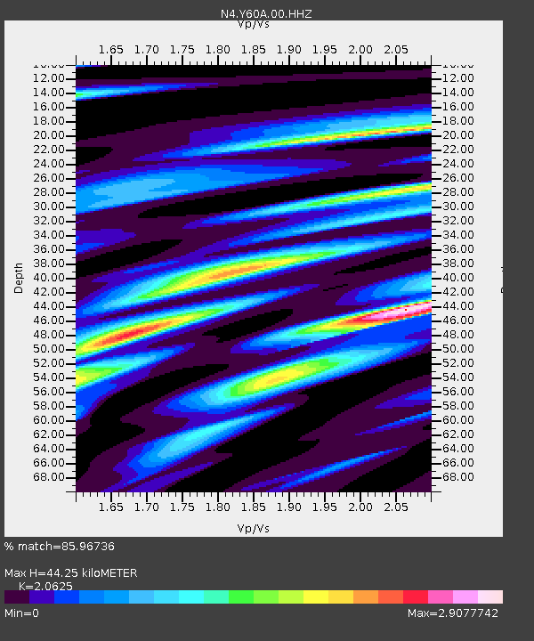
| Estimated Moho Depth: |
44.25 km |
| Estimated Crust Vp/Vs: |
2.06 |
| Assumed Crust Vp: |
6.565 km/s |
| Estimated Crust Vs: |
3.183 km/s |
| Estimated Crust Poisson's Ratio: |
0.35 |
|
| Radial Match: |
85.96736 % |
| Radial Bump: |
400 |
| Transverse Match: |
59.791096 % |
| Transverse Bump: |
392 |
| SOD ConfigId: |
25131211 |
| Insert Time: |
2021-08-13 17:33:58.662 +0000 |
| GWidth: |
2.5 |
| Max Bumps: |
400 |
| Tol: |
0.001 |
|

Signal To Noise
| Channel | StoN | STA | LTA |
| N4:Y60A:00:HHZ:20210730T17:17:10.450005Z | 11.035761 | 3.3369386E-6 | 3.0237504E-7 |
| N4:Y60A:00:HH1:20210730T17:17:10.450005Z | 4.340012 | 4.6599243E-6 | 1.0737124E-6 |
| N4:Y60A:00:HH2:20210730T17:17:10.450005Z | 2.2261386 | 1.3199062E-6 | 5.929129E-7 |
| Arrivals |
| Ps | 7.6 SECOND |
| PpPs | 19 SECOND |
| PsPs/PpSs | 27 SECOND |


