You are here: Home > Network List > NN - Western Great Basin/Eastern Sierra Nevada Stations List
> Station GMN Gold Mountain, NV, USA > Earthquake Result Viewer
GMN Gold Mountain, NV, USA - Earthquake Result Viewer
| Earthquake location: |
Peru-Ecuador Border Region |
| Earthquake latitude/longitude: |
-4.9/-80.6 |
| Earthquake time(UTC): |
2021/07/30 (211) 17:10:19 GMT |
| Earthquake Depth: |
33 km |
| Earthquake Magnitude: |
6.2 Mww |
| Earthquake Catalog/Contributor: |
NEIC PDE/us |
|
| Network: |
NN Western Great Basin/Eastern Sierra Nevada |
| Station: |
GMN Gold Mountain, NV, USA |
| Lat/Lon: |
37.30 N/117.26 W |
| Elevation: |
2168 m |
|
| Distance: |
54.1 deg |
| Az: |
324.024 deg |
| Baz: |
132.778 deg |
| Ray Param: |
0.06558973 |
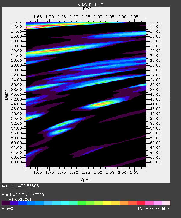
| Estimated Moho Depth: |
12.0 km |
| Estimated Crust Vp/Vs: |
1.60 |
| Assumed Crust Vp: |
6.279 km/s |
| Estimated Crust Vs: |
3.918 km/s |
| Estimated Crust Poisson's Ratio: |
0.18 |
|
| Radial Match: |
83.55506 % |
| Radial Bump: |
400 |
| Transverse Match: |
77.63315 % |
| Transverse Bump: |
400 |
| SOD ConfigId: |
25131211 |
| Insert Time: |
2021-08-13 17:34:45.946 +0000 |
| GWidth: |
2.5 |
| Max Bumps: |
400 |
| Tol: |
0.001 |
|

Signal To Noise
| Channel | StoN | STA | LTA |
| NN:GMN: :HHZ:20210730T17:19:10.549981Z | 72.35006 | 4.085108E-6 | 5.6463087E-8 |
| NN:GMN: :HHN:20210730T17:19:10.549981Z | 5.2562213 | 1.3855847E-6 | 2.636085E-7 |
| NN:GMN: :HHE:20210730T17:19:10.549981Z | 13.895354 | 1.4726799E-6 | 1.0598361E-7 |
| Arrivals |
| Ps | 1.2 SECOND |
| PpPs | 4.7 SECOND |
| PsPs/PpSs | 5.9 SECOND |


