You are here: Home > Network List > NN - Western Great Basin/Eastern Sierra Nevada Stations List
> Station MCM08 Monte Cristo Menlo 08 > Earthquake Result Viewer
MCM08 Monte Cristo Menlo 08 - Earthquake Result Viewer
| Earthquake location: |
Peru-Ecuador Border Region |
| Earthquake latitude/longitude: |
-4.9/-80.6 |
| Earthquake time(UTC): |
2021/07/30 (211) 17:10:19 GMT |
| Earthquake Depth: |
33 km |
| Earthquake Magnitude: |
6.2 Mww |
| Earthquake Catalog/Contributor: |
NEIC PDE/us |
|
| Network: |
NN Western Great Basin/Eastern Sierra Nevada |
| Station: |
MCM08 Monte Cristo Menlo 08 |
| Lat/Lon: |
38.16 N/118.05 W |
| Elevation: |
1669 m |
|
| Distance: |
55.2 deg |
| Az: |
324.277 deg |
| Baz: |
132.443 deg |
| Ray Param: |
0.06490264 |
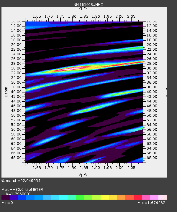
| Estimated Moho Depth: |
30.0 km |
| Estimated Crust Vp/Vs: |
1.80 |
| Assumed Crust Vp: |
6.279 km/s |
| Estimated Crust Vs: |
3.498 km/s |
| Estimated Crust Poisson's Ratio: |
0.27 |
|
| Radial Match: |
92.049034 % |
| Radial Bump: |
400 |
| Transverse Match: |
92.14623 % |
| Transverse Bump: |
400 |
| SOD ConfigId: |
25131211 |
| Insert Time: |
2021-08-13 17:34:58.317 +0000 |
| GWidth: |
2.5 |
| Max Bumps: |
400 |
| Tol: |
0.001 |
|

Signal To Noise
| Channel | StoN | STA | LTA |
| NN:MCM08: :HHZ:20210730T17:19:18.10003Z | 172.73647 | 6.269558E-6 | 3.629551E-8 |
| NN:MCM08: :HHN:20210730T17:19:18.10003Z | 31.832647 | 1.5158756E-6 | 4.7620155E-8 |
| NN:MCM08: :HHE:20210730T17:19:18.10003Z | 54.53002 | 2.3901484E-6 | 4.383179E-8 |
| Arrivals |
| Ps | 4.0 SECOND |
| PpPs | 13 SECOND |
| PsPs/PpSs | 17 SECOND |


