You are here: Home > Network List > NN - Western Great Basin/Eastern Sierra Nevada Stations List
> Station WDEM Washoe County DEM, Nevada > Earthquake Result Viewer
WDEM Washoe County DEM, Nevada - Earthquake Result Viewer
| Earthquake location: |
Peru-Ecuador Border Region |
| Earthquake latitude/longitude: |
-4.9/-80.6 |
| Earthquake time(UTC): |
2021/07/30 (211) 17:10:19 GMT |
| Earthquake Depth: |
33 km |
| Earthquake Magnitude: |
6.2 Mww |
| Earthquake Catalog/Contributor: |
NEIC PDE/us |
|
| Network: |
NN Western Great Basin/Eastern Sierra Nevada |
| Station: |
WDEM Washoe County DEM, Nevada |
| Lat/Lon: |
39.58 N/119.81 W |
| Elevation: |
1572 m |
|
| Distance: |
57.2 deg |
| Az: |
324.447 deg |
| Baz: |
131.438 deg |
| Ray Param: |
0.06362045 |
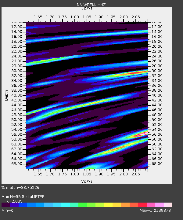
| Estimated Moho Depth: |
55.5 km |
| Estimated Crust Vp/Vs: |
2.09 |
| Assumed Crust Vp: |
6.279 km/s |
| Estimated Crust Vs: |
3.011 km/s |
| Estimated Crust Poisson's Ratio: |
0.35 |
|
| Radial Match: |
88.75226 % |
| Radial Bump: |
389 |
| Transverse Match: |
83.155624 % |
| Transverse Bump: |
400 |
| SOD ConfigId: |
25131211 |
| Insert Time: |
2021-08-13 17:35:23.264 +0000 |
| GWidth: |
2.5 |
| Max Bumps: |
400 |
| Tol: |
0.001 |
|

Signal To Noise
| Channel | StoN | STA | LTA |
| NN:WDEM: :HHZ:20210730T17:19:32.137994Z | 32.963985 | 3.69137E-6 | 1.11981905E-7 |
| NN:WDEM: :HHN:20210730T17:19:32.137994Z | 7.7029095 | 1.0809235E-6 | 1.4032665E-7 |
| NN:WDEM: :HHE:20210730T17:19:32.137994Z | 7.786901 | 9.588558E-7 | 1.2313703E-7 |
| Arrivals |
| Ps | 10.0 SECOND |
| PpPs | 26 SECOND |
| PsPs/PpSs | 36 SECOND |


