You are here: Home > Network List > NW - Northwestern University Seismic Network Stations List
> Station L44A Ryerson Woods, Lake Cnty Forest Preserve, IL, USA > Earthquake Result Viewer
L44A Ryerson Woods, Lake Cnty Forest Preserve, IL, USA - Earthquake Result Viewer
| Earthquake location: |
Peru-Ecuador Border Region |
| Earthquake latitude/longitude: |
-4.9/-80.6 |
| Earthquake time(UTC): |
2021/07/30 (211) 17:10:19 GMT |
| Earthquake Depth: |
33 km |
| Earthquake Magnitude: |
6.2 Mww |
| Earthquake Catalog/Contributor: |
NEIC PDE/us |
|
| Network: |
NW Northwestern University Seismic Network |
| Station: |
L44A Ryerson Woods, Lake Cnty Forest Preserve, IL, USA |
| Lat/Lon: |
42.18 N/87.91 W |
| Elevation: |
202 m |
|
| Distance: |
47.4 deg |
| Az: |
352.614 deg |
| Baz: |
170.077 deg |
| Ray Param: |
0.06997842 |
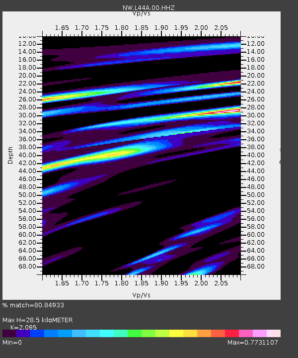
| Estimated Moho Depth: |
28.5 km |
| Estimated Crust Vp/Vs: |
2.10 |
| Assumed Crust Vp: |
6.483 km/s |
| Estimated Crust Vs: |
3.094 km/s |
| Estimated Crust Poisson's Ratio: |
0.35 |
|
| Radial Match: |
80.84933 % |
| Radial Bump: |
400 |
| Transverse Match: |
65.34593 % |
| Transverse Bump: |
400 |
| SOD ConfigId: |
25131211 |
| Insert Time: |
2021-08-13 17:35:38.436 +0000 |
| GWidth: |
2.5 |
| Max Bumps: |
400 |
| Tol: |
0.001 |
|

Signal To Noise
| Channel | StoN | STA | LTA |
| NW:L44A:00:HHZ:20210730T17:18:19.568993Z | 8.914843 | 2.4271678E-6 | 2.7226145E-7 |
| NW:L44A:00:HH1:20210730T17:18:19.568993Z | 5.0706515 | 1.8255411E-6 | 3.6002103E-7 |
| NW:L44A:00:HH2:20210730T17:18:19.568993Z | 1.2292043 | 5.3577793E-7 | 4.358738E-7 |
| Arrivals |
| Ps | 5.1 SECOND |
| PpPs | 13 SECOND |
| PsPs/PpSs | 18 SECOND |


