You are here: Home > Network List > TX - Texas Seismological Network Stations List
> Station SN01 Snyder 1 > Earthquake Result Viewer
SN01 Snyder 1 - Earthquake Result Viewer
| Earthquake location: |
Komandorskiye Ostrova Region |
| Earthquake latitude/longitude: |
55.4/166.5 |
| Earthquake time(UTC): |
2018/01/25 (025) 02:10:33 GMT |
| Earthquake Depth: |
8.8 km |
| Earthquake Magnitude: |
6.2 Mww |
| Earthquake Catalog/Contributor: |
NEIC PDE/us |
|
| Network: |
TX Texas Seismological Network |
| Station: |
SN01 Snyder 1 |
| Lat/Lon: |
32.86 N/100.89 W |
| Elevation: |
717 m |
|
| Distance: |
65.1 deg |
| Az: |
67.994 deg |
| Baz: |
321.073 deg |
| Ray Param: |
0.058516704 |
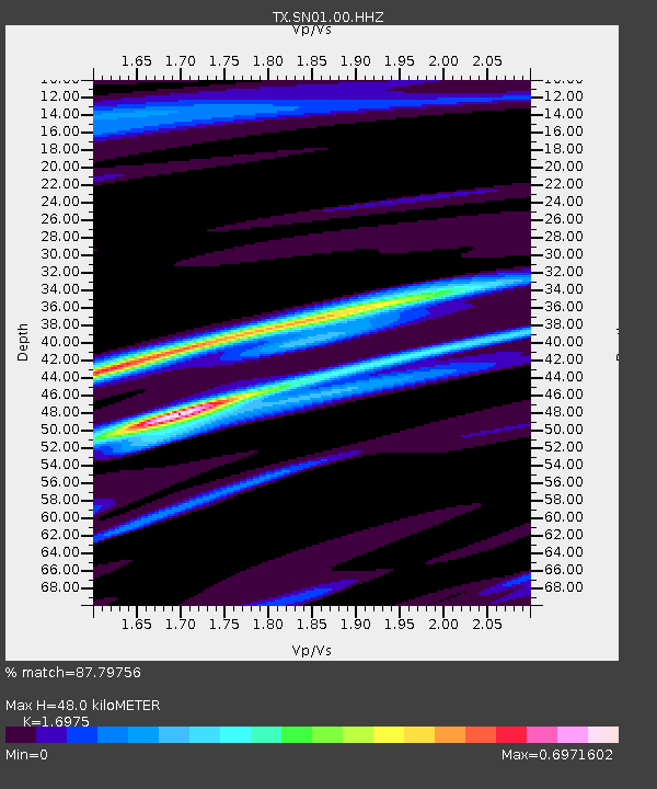
| Estimated Moho Depth: |
48.0 km |
| Estimated Crust Vp/Vs: |
1.70 |
| Assumed Crust Vp: |
6.426 km/s |
| Estimated Crust Vs: |
3.786 km/s |
| Estimated Crust Poisson's Ratio: |
0.23 |
|
| Radial Match: |
87.79756 % |
| Radial Bump: |
228 |
| Transverse Match: |
86.09824 % |
| Transverse Bump: |
325 |
| SOD ConfigId: |
2546091 |
| Insert Time: |
2018-02-08 02:15:27.947 +0000 |
| GWidth: |
2.5 |
| Max Bumps: |
400 |
| Tol: |
0.001 |
|
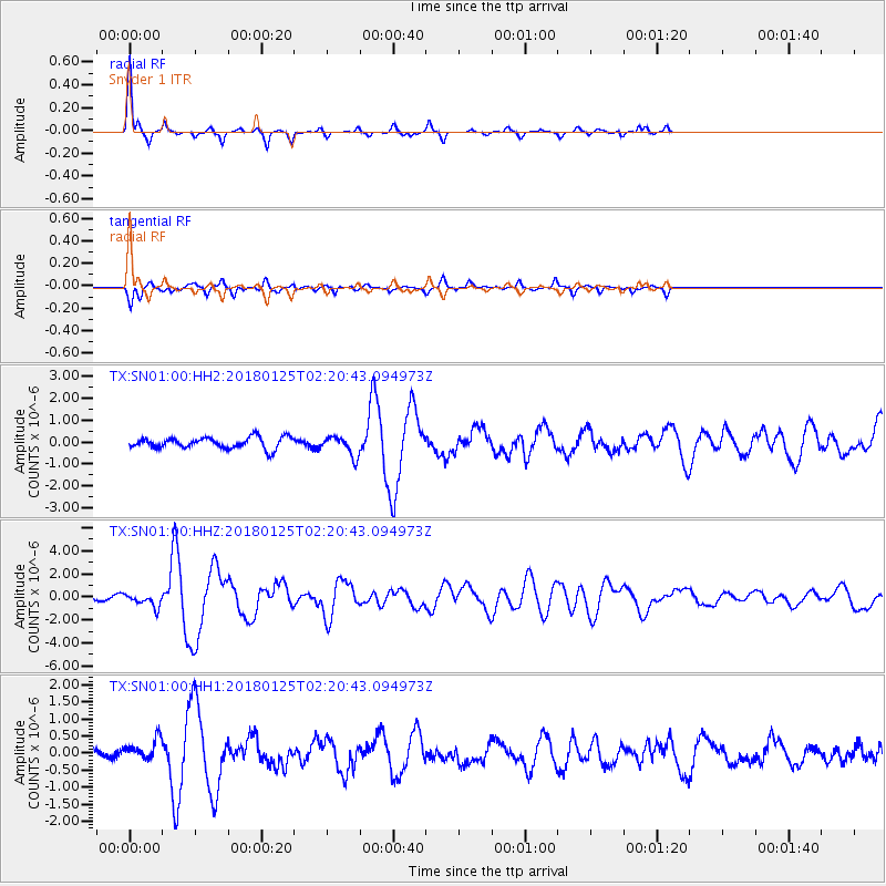
Signal To Noise
| Channel | StoN | STA | LTA |
| TX:SN01:00:HHZ:20180125T02:20:43.094973Z | 2.1040237 | 5.858327E-7 | 2.7843447E-7 |
| TX:SN01:00:HH1:20180125T02:20:43.094973Z | 1.2455466 | 3.0349057E-7 | 2.4366057E-7 |
| TX:SN01:00:HH2:20180125T02:20:43.094973Z | 1.7809979 | 4.549431E-7 | 2.554428E-7 |
| Arrivals |
| Ps | 5.4 SECOND |
| PpPs | 19 SECOND |
| PsPs/PpSs | 25 SECOND |


