You are here: Home > Network List > O2 - Oklahoma Consolidated Temporary Seismic Networks Stations List
> Station PW19 Marland, Oklahoma, USA > Earthquake Result Viewer
PW19 Marland, Oklahoma, USA - Earthquake Result Viewer
| Earthquake location: |
Peru-Ecuador Border Region |
| Earthquake latitude/longitude: |
-4.9/-80.6 |
| Earthquake time(UTC): |
2021/07/30 (211) 17:10:19 GMT |
| Earthquake Depth: |
33 km |
| Earthquake Magnitude: |
6.2 Mww |
| Earthquake Catalog/Contributor: |
NEIC PDE/us |
|
| Network: |
O2 Oklahoma Consolidated Temporary Seismic Networks |
| Station: |
PW19 Marland, Oklahoma, USA |
| Lat/Lon: |
36.57 N/97.04 W |
| Elevation: |
301 m |
|
| Distance: |
44.1 deg |
| Az: |
340.881 deg |
| Baz: |
156.087 deg |
| Ray Param: |
0.0721041 |
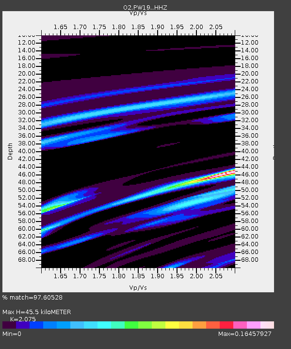
| Estimated Moho Depth: |
45.5 km |
| Estimated Crust Vp/Vs: |
2.08 |
| Assumed Crust Vp: |
6.483 km/s |
| Estimated Crust Vs: |
3.124 km/s |
| Estimated Crust Poisson's Ratio: |
0.35 |
|
| Radial Match: |
97.60528 % |
| Radial Bump: |
158 |
| Transverse Match: |
97.605286 % |
| Transverse Bump: |
158 |
| SOD ConfigId: |
25131211 |
| Insert Time: |
2021-08-13 17:36:39.636 +0000 |
| GWidth: |
2.5 |
| Max Bumps: |
400 |
| Tol: |
0.001 |
|

Signal To Noise
| Channel | StoN | STA | LTA |
| O2:PW19: :HHZ:20210730T17:17:53.520013Z | 11.526416 | 1.8880763E-6 | 1.638043E-7 |
| $trig.getChannelId() | $trig.getValue() | $trig.getSTA() | $trig.getLTA() |
| O2:PW19: :HHE:20210730T17:17:53.520013Z | 13.177788 | 2.640177E-6 | 2.0035053E-7 |
| Arrivals |
| Ps | 8.0 SECOND |
| PpPs | 20 SECOND |
| PsPs/PpSs | 28 SECOND |


