You are here: Home > Network List > O2 - Oklahoma Consolidated Temporary Seismic Networks Stations List
> Station RNSP Roman Nose State Park, Oklahoma, USA > Earthquake Result Viewer
RNSP Roman Nose State Park, Oklahoma, USA - Earthquake Result Viewer
| Earthquake location: |
Peru-Ecuador Border Region |
| Earthquake latitude/longitude: |
-4.9/-80.6 |
| Earthquake time(UTC): |
2021/07/30 (211) 17:10:19 GMT |
| Earthquake Depth: |
33 km |
| Earthquake Magnitude: |
6.2 Mww |
| Earthquake Catalog/Contributor: |
NEIC PDE/us |
|
| Network: |
O2 Oklahoma Consolidated Temporary Seismic Networks |
| Station: |
RNSP Roman Nose State Park, Oklahoma, USA |
| Lat/Lon: |
35.93 N/98.43 W |
| Elevation: |
453 m |
|
| Distance: |
44.0 deg |
| Az: |
339.03 deg |
| Baz: |
153.937 deg |
| Ray Param: |
0.072160594 |
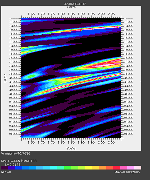
| Estimated Moho Depth: |
33.5 km |
| Estimated Crust Vp/Vs: |
2.02 |
| Assumed Crust Vp: |
6.315 km/s |
| Estimated Crust Vs: |
3.13 km/s |
| Estimated Crust Poisson's Ratio: |
0.34 |
|
| Radial Match: |
90.7636 % |
| Radial Bump: |
400 |
| Transverse Match: |
72.016945 % |
| Transverse Bump: |
400 |
| SOD ConfigId: |
25131211 |
| Insert Time: |
2021-08-13 17:36:43.950 +0000 |
| GWidth: |
2.5 |
| Max Bumps: |
400 |
| Tol: |
0.001 |
|

Signal To Noise
| Channel | StoN | STA | LTA |
| O2:RNSP: :HHZ:20210730T17:17:52.724999Z | 42.354805 | 6.600614E-6 | 1.5584098E-7 |
| O2:RNSP: :HHN:20210730T17:17:52.724999Z | 10.029882 | 1.900872E-6 | 1.8952088E-7 |
| O2:RNSP: :HHE:20210730T17:17:52.724999Z | 14.25296 | 1.5421E-6 | 1.0819506E-7 |
| Arrivals |
| Ps | 5.7 SECOND |
| PpPs | 15 SECOND |
| PsPs/PpSs | 21 SECOND |


