You are here: Home > Network List > TX - Texas Seismological Network Stations List
> Station SN04 Snyder 4 > Earthquake Result Viewer
SN04 Snyder 4 - Earthquake Result Viewer
| Earthquake location: |
Komandorskiye Ostrova Region |
| Earthquake latitude/longitude: |
55.4/166.5 |
| Earthquake time(UTC): |
2018/01/25 (025) 02:10:33 GMT |
| Earthquake Depth: |
8.8 km |
| Earthquake Magnitude: |
6.2 Mww |
| Earthquake Catalog/Contributor: |
NEIC PDE/us |
|
| Network: |
TX Texas Seismological Network |
| Station: |
SN04 Snyder 4 |
| Lat/Lon: |
32.90 N/100.87 W |
| Elevation: |
716 m |
|
| Distance: |
65.1 deg |
| Az: |
67.954 deg |
| Baz: |
321.067 deg |
| Ray Param: |
0.05852865 |
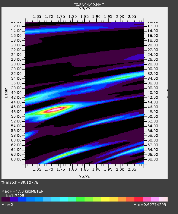
| Estimated Moho Depth: |
47.0 km |
| Estimated Crust Vp/Vs: |
1.72 |
| Assumed Crust Vp: |
6.426 km/s |
| Estimated Crust Vs: |
3.731 km/s |
| Estimated Crust Poisson's Ratio: |
0.25 |
|
| Radial Match: |
89.10776 % |
| Radial Bump: |
316 |
| Transverse Match: |
82.26011 % |
| Transverse Bump: |
360 |
| SOD ConfigId: |
2546091 |
| Insert Time: |
2018-02-08 02:15:33.791 +0000 |
| GWidth: |
2.5 |
| Max Bumps: |
400 |
| Tol: |
0.001 |
|
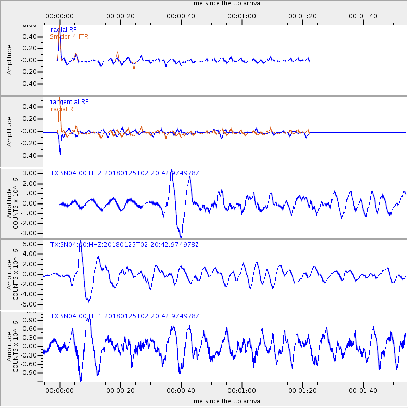
Signal To Noise
| Channel | StoN | STA | LTA |
| TX:SN04:00:HHZ:20180125T02:20:42.974978Z | 2.3018265 | 7.127094E-7 | 3.0962778E-7 |
| TX:SN04:00:HH1:20180125T02:20:42.974978Z | 1.3606454 | 2.2755411E-7 | 1.6723982E-7 |
| TX:SN04:00:HH2:20180125T02:20:42.974978Z | 1.4589442 | 4.5207466E-7 | 3.0986425E-7 |
| Arrivals |
| Ps | 5.5 SECOND |
| PpPs | 19 SECOND |
| PsPs/PpSs | 25 SECOND |


