You are here: Home > Network List > OH - Ohio Seismic Network Stations List
> Station CPOH Chapparal Prarie > Earthquake Result Viewer
CPOH Chapparal Prarie - Earthquake Result Viewer
| Earthquake location: |
Peru-Ecuador Border Region |
| Earthquake latitude/longitude: |
-4.9/-80.6 |
| Earthquake time(UTC): |
2021/07/30 (211) 17:10:19 GMT |
| Earthquake Depth: |
33 km |
| Earthquake Magnitude: |
6.2 Mww |
| Earthquake Catalog/Contributor: |
NEIC PDE/us |
|
| Network: |
OH Ohio Seismic Network |
| Station: |
CPOH Chapparal Prarie |
| Lat/Lon: |
38.84 N/83.58 W |
| Elevation: |
289 m |
|
| Distance: |
43.6 deg |
| Az: |
356.633 deg |
| Baz: |
175.702 deg |
| Ray Param: |
0.072356015 |
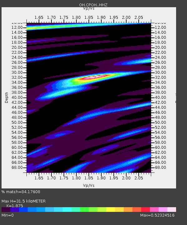
| Estimated Moho Depth: |
31.5 km |
| Estimated Crust Vp/Vs: |
1.88 |
| Assumed Crust Vp: |
6.232 km/s |
| Estimated Crust Vs: |
3.324 km/s |
| Estimated Crust Poisson's Ratio: |
0.30 |
|
| Radial Match: |
84.17608 % |
| Radial Bump: |
400 |
| Transverse Match: |
58.053795 % |
| Transverse Bump: |
400 |
| SOD ConfigId: |
25131211 |
| Insert Time: |
2021-08-13 17:37:26.631 +0000 |
| GWidth: |
2.5 |
| Max Bumps: |
400 |
| Tol: |
0.001 |
|

Signal To Noise
| Channel | StoN | STA | LTA |
| OH:CPOH: :HHZ:20210730T17:17:50.200005Z | 44.627563 | 1.0603213E-7 | 2.3759337E-9 |
| OH:CPOH: :HHN:20210730T17:17:50.200005Z | 9.634912 | 5.72581E-8 | 5.942774E-9 |
| OH:CPOH: :HHE:20210730T17:17:50.200005Z | 1.3438841 | 1.3268113E-8 | 9.872959E-9 |
| Arrivals |
| Ps | 4.7 SECOND |
| PpPs | 14 SECOND |
| PsPs/PpSs | 18 SECOND |


