You are here: Home > Network List > OH - Ohio Seismic Network Stations List
> Station MWLO Mercer Wildlife Area Ohio > Earthquake Result Viewer
MWLO Mercer Wildlife Area Ohio - Earthquake Result Viewer
| Earthquake location: |
Peru-Ecuador Border Region |
| Earthquake latitude/longitude: |
-4.9/-80.6 |
| Earthquake time(UTC): |
2021/07/30 (211) 17:10:19 GMT |
| Earthquake Depth: |
33 km |
| Earthquake Magnitude: |
6.2 Mww |
| Earthquake Catalog/Contributor: |
NEIC PDE/us |
|
| Network: |
OH Ohio Seismic Network |
| Station: |
MWLO Mercer Wildlife Area Ohio |
| Lat/Lon: |
40.50 N/84.57 W |
| Elevation: |
266 m |
|
| Distance: |
45.4 deg |
| Az: |
355.749 deg |
| Baz: |
174.442 deg |
| Ray Param: |
0.07126834 |
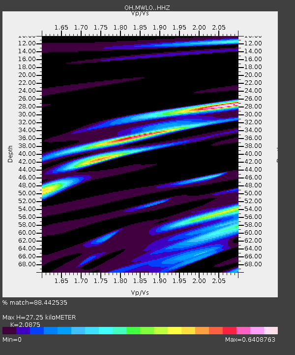
| Estimated Moho Depth: |
27.25 km |
| Estimated Crust Vp/Vs: |
2.09 |
| Assumed Crust Vp: |
6.498 km/s |
| Estimated Crust Vs: |
3.113 km/s |
| Estimated Crust Poisson's Ratio: |
0.35 |
|
| Radial Match: |
88.442535 % |
| Radial Bump: |
400 |
| Transverse Match: |
61.68974 % |
| Transverse Bump: |
400 |
| SOD ConfigId: |
25131211 |
| Insert Time: |
2021-08-13 17:37:31.591 +0000 |
| GWidth: |
2.5 |
| Max Bumps: |
400 |
| Tol: |
0.001 |
|

Signal To Noise
| Channel | StoN | STA | LTA |
| OH:MWLO: :HHZ:20210730T17:18:03.909997Z | 15.938129 | 2.842421E-6 | 1.7834094E-7 |
| OH:MWLO: :HHN:20210730T17:18:03.909997Z | 7.4781256 | 1.5123027E-6 | 2.0223018E-7 |
| OH:MWLO: :HHE:20210730T17:18:03.909997Z | 2.2614927 | 3.8952106E-7 | 1.7224069E-7 |
| Arrivals |
| Ps | 4.8 SECOND |
| PpPs | 12 SECOND |
| PsPs/PpSs | 17 SECOND |


