You are here: Home > Network List > OK - Oklahoma Seismic Network Stations List
> Station W35A Tecumseh, Oklahoma, USA > Earthquake Result Viewer
W35A Tecumseh, Oklahoma, USA - Earthquake Result Viewer
| Earthquake location: |
Peru-Ecuador Border Region |
| Earthquake latitude/longitude: |
-4.9/-80.6 |
| Earthquake time(UTC): |
2021/07/30 (211) 17:10:19 GMT |
| Earthquake Depth: |
33 km |
| Earthquake Magnitude: |
6.2 Mww |
| Earthquake Catalog/Contributor: |
NEIC PDE/us |
|
| Network: |
OK Oklahoma Seismic Network |
| Station: |
W35A Tecumseh, Oklahoma, USA |
| Lat/Lon: |
35.15 N/96.87 W |
| Elevation: |
322 m |
|
| Distance: |
42.7 deg |
| Az: |
340.215 deg |
| Baz: |
155.697 deg |
| Ray Param: |
0.07294979 |
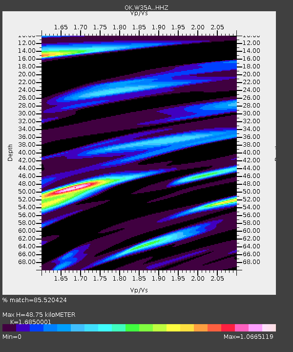
| Estimated Moho Depth: |
48.75 km |
| Estimated Crust Vp/Vs: |
1.69 |
| Assumed Crust Vp: |
6.426 km/s |
| Estimated Crust Vs: |
3.814 km/s |
| Estimated Crust Poisson's Ratio: |
0.23 |
|
| Radial Match: |
85.520424 % |
| Radial Bump: |
376 |
| Transverse Match: |
77.21316 % |
| Transverse Bump: |
374 |
| SOD ConfigId: |
25131211 |
| Insert Time: |
2021-08-13 17:38:02.694 +0000 |
| GWidth: |
2.5 |
| Max Bumps: |
400 |
| Tol: |
0.001 |
|

Signal To Noise
| Channel | StoN | STA | LTA |
| OK:W35A: :HHZ:20210730T17:17:42.71499Z | 84.704185 | 5.0079557E-6 | 5.912288E-8 |
| OK:W35A: :HHN:20210730T17:17:42.71499Z | 14.497018 | 1.9517265E-6 | 1.3462952E-7 |
| OK:W35A: :HHE:20210730T17:17:42.71499Z | 8.88824 | 9.654052E-7 | 1.0861601E-7 |
| Arrivals |
| Ps | 5.6 SECOND |
| PpPs | 19 SECOND |
| PsPs/PpSs | 25 SECOND |


