You are here: Home > Network List > PY - PFO Array Stations List
> Station BPH03 Pinon Flat Observatory, CA, USA > Earthquake Result Viewer
BPH03 Pinon Flat Observatory, CA, USA - Earthquake Result Viewer
| Earthquake location: |
Peru-Ecuador Border Region |
| Earthquake latitude/longitude: |
-4.9/-80.6 |
| Earthquake time(UTC): |
2021/07/30 (211) 17:10:19 GMT |
| Earthquake Depth: |
33 km |
| Earthquake Magnitude: |
6.2 Mww |
| Earthquake Catalog/Contributor: |
NEIC PDE/us |
|
| Network: |
PY PFO Array |
| Station: |
BPH03 Pinon Flat Observatory, CA, USA |
| Lat/Lon: |
33.61 N/116.46 W |
| Elevation: |
1285 m |
|
| Distance: |
51.2 deg |
| Az: |
321.145 deg |
| Baz: |
131.497 deg |
| Ray Param: |
0.06752287 |
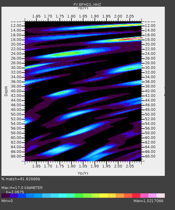
| Estimated Moho Depth: |
17.0 km |
| Estimated Crust Vp/Vs: |
2.10 |
| Assumed Crust Vp: |
6.264 km/s |
| Estimated Crust Vs: |
2.986 km/s |
| Estimated Crust Poisson's Ratio: |
0.35 |
|
| Radial Match: |
91.928696 % |
| Radial Bump: |
400 |
| Transverse Match: |
73.73846 % |
| Transverse Bump: |
400 |
| SOD ConfigId: |
25131211 |
| Insert Time: |
2021-08-13 17:39:35.070 +0000 |
| GWidth: |
2.5 |
| Max Bumps: |
400 |
| Tol: |
0.001 |
|

Signal To Noise
| Channel | StoN | STA | LTA |
| PY:BPH03: :HHZ:20210730T17:18:48.715997Z | 39.702736 | 2.8256939E-6 | 7.1171264E-8 |
| PY:BPH03: :HHN:20210730T17:18:48.715997Z | 17.862946 | 8.8931205E-7 | 4.97853E-8 |
| PY:BPH03: :HHE:20210730T17:18:48.715997Z | 22.090225 | 1.2543076E-6 | 5.678111E-8 |
| Arrivals |
| Ps | 3.1 SECOND |
| PpPs | 8.0 SECOND |
| PsPs/PpSs | 11 SECOND |


