You are here: Home > Network List > RV - Regional Alberta Seismic Observatory for Earthquake Studies Network Stations List
> Station EGLEA Eagle Lookout Tower, AB > Earthquake Result Viewer
EGLEA Eagle Lookout Tower, AB - Earthquake Result Viewer
| Earthquake location: |
Peru-Ecuador Border Region |
| Earthquake latitude/longitude: |
-4.9/-80.6 |
| Earthquake time(UTC): |
2021/07/30 (211) 17:10:19 GMT |
| Earthquake Depth: |
33 km |
| Earthquake Magnitude: |
6.2 Mww |
| Earthquake Catalog/Contributor: |
NEIC PDE/us |
|
| Network: |
RV Regional Alberta Seismic Observatory for Earthquake Studies Network |
| Station: |
EGLEA Eagle Lookout Tower, AB |
| Lat/Lon: |
54.46 N/116.44 W |
| Elevation: |
1056 m |
|
| Distance: |
66.3 deg |
| Az: |
338.074 deg |
| Baz: |
140.418 deg |
| Ray Param: |
0.05767039 |
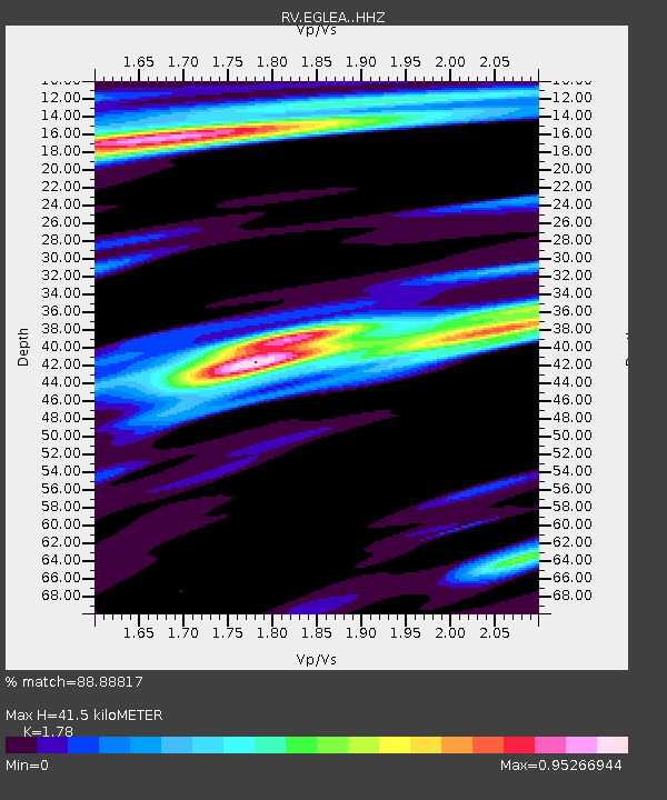
| Estimated Moho Depth: |
41.5 km |
| Estimated Crust Vp/Vs: |
1.78 |
| Assumed Crust Vp: |
6.426 km/s |
| Estimated Crust Vs: |
3.61 km/s |
| Estimated Crust Poisson's Ratio: |
0.27 |
|
| Radial Match: |
88.88817 % |
| Radial Bump: |
356 |
| Transverse Match: |
55.387882 % |
| Transverse Bump: |
400 |
| SOD ConfigId: |
25131211 |
| Insert Time: |
2021-08-13 17:40:06.164 +0000 |
| GWidth: |
2.5 |
| Max Bumps: |
400 |
| Tol: |
0.001 |
|

Signal To Noise
| Channel | StoN | STA | LTA |
| RV:EGLEA: :HHZ:20210730T17:20:33.470025Z | 17.631756 | 3.7622924E-6 | 2.133816E-7 |
| RV:EGLEA: :HHN:20210730T17:20:33.470025Z | 3.095499 | 1.217946E-6 | 3.9345704E-7 |
| RV:EGLEA: :HHE:20210730T17:20:33.470025Z | 4.181962 | 1.1313653E-6 | 2.7053457E-7 |
| Arrivals |
| Ps | 5.2 SECOND |
| PpPs | 17 SECOND |
| PsPs/PpSs | 22 SECOND |


