You are here: Home > Network List > RV - Regional Alberta Seismic Observatory for Earthquake Studies Network Stations List
> Station PKSKA Pekisko, AB > Earthquake Result Viewer
PKSKA Pekisko, AB - Earthquake Result Viewer
| Earthquake location: |
Peru-Ecuador Border Region |
| Earthquake latitude/longitude: |
-4.9/-80.6 |
| Earthquake time(UTC): |
2021/07/30 (211) 17:10:19 GMT |
| Earthquake Depth: |
33 km |
| Earthquake Magnitude: |
6.2 Mww |
| Earthquake Catalog/Contributor: |
NEIC PDE/us |
|
| Network: |
RV Regional Alberta Seismic Observatory for Earthquake Studies Network |
| Station: |
PKSKA Pekisko, AB |
| Lat/Lon: |
50.43 N/114.12 W |
| Elevation: |
1231 m |
|
| Distance: |
62.3 deg |
| Az: |
336.482 deg |
| Baz: |
141.561 deg |
| Ray Param: |
0.060295142 |
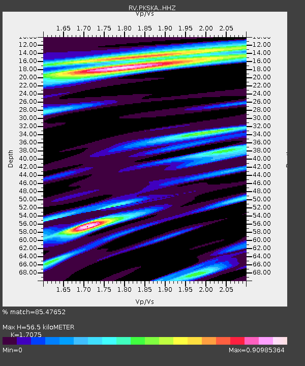
| Estimated Moho Depth: |
56.5 km |
| Estimated Crust Vp/Vs: |
1.71 |
| Assumed Crust Vp: |
6.178 km/s |
| Estimated Crust Vs: |
3.618 km/s |
| Estimated Crust Poisson's Ratio: |
0.24 |
|
| Radial Match: |
85.47652 % |
| Radial Bump: |
400 |
| Transverse Match: |
64.08257 % |
| Transverse Bump: |
400 |
| SOD ConfigId: |
25131211 |
| Insert Time: |
2021-08-13 17:40:12.394 +0000 |
| GWidth: |
2.5 |
| Max Bumps: |
400 |
| Tol: |
0.001 |
|

Signal To Noise
| Channel | StoN | STA | LTA |
| RV:PKSKA: :HHZ:20210730T17:20:07.169976Z | 12.225343 | 2.8047566E-6 | 2.2942152E-7 |
| RV:PKSKA: :HHN:20210730T17:20:07.169976Z | 3.0908954 | 5.0735474E-7 | 1.6414491E-7 |
| RV:PKSKA: :HHE:20210730T17:20:07.169976Z | 2.706658 | 7.0353406E-7 | 2.5992722E-7 |
| Arrivals |
| Ps | 6.8 SECOND |
| PpPs | 24 SECOND |
| PsPs/PpSs | 30 SECOND |


