You are here: Home > Network List > TX - Texas Seismological Network Stations List
> Station 435B Jarrell, TX, USA > Earthquake Result Viewer
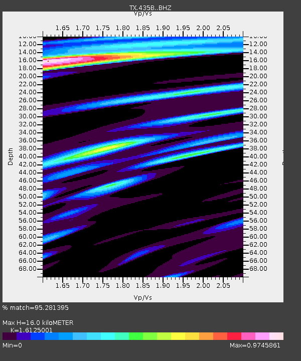
435B Jarrell, TX, USA - Earthquake Result Viewer
| Earthquake location: |
Peru-Ecuador Border Region |
| Earthquake latitude/longitude: |
-4.9/-80.6 |
| Earthquake time(UTC): |
2021/07/30 (211) 17:10:19 GMT |
| Earthquake Depth: |
33 km |
| Earthquake Magnitude: |
6.2 Mww |
| Earthquake Catalog/Contributor: |
NEIC PDE/us |
|
| Network: |
TX Texas Seismological Network |
| Station: |
435B Jarrell, TX, USA |
| Lat/Lon: |
30.78 N/97.58 W |
| Elevation: |
248 m |
|
| Distance: |
39.1 deg |
| Az: |
336.485 deg |
| Baz: |
152.49 deg |
| Ray Param: |
0.07516517 |
| Estimated Moho Depth: |
16.0 km |
| Estimated Crust Vp/Vs: |
1.61 |
| Assumed Crust Vp: |
6.347 km/s |
| Estimated Crust Vs: |
3.936 km/s |
| Estimated Crust Poisson's Ratio: |
0.19 |
|
| Radial Match: |
95.281395 % |
| Radial Bump: |
384 |
| Transverse Match: |
91.566376 % |
| Transverse Bump: |
400 |
| SOD ConfigId: |
25131211 |
| Insert Time: |
2021-08-13 17:41:13.508 +0000 |
| GWidth: |
2.5 |
| Max Bumps: |
400 |
| Tol: |
0.001 |
|

Signal To Noise
| Channel | StoN | STA | LTA |
| TX:435B: :BHZ:20210730T17:17:12.623986Z | 31.931812 | 5.542783E-6 | 1.7358185E-7 |
| TX:435B: :BHN:20210730T17:17:12.623986Z | 28.731894 | 2.6844393E-6 | 9.343064E-8 |
| TX:435B: :BHE:20210730T17:17:12.623986Z | 12.835831 | 1.1461735E-6 | 8.929485E-8 |
| Arrivals |
| Ps | 1.7 SECOND |
| PpPs | 6.1 SECOND |
| PsPs/PpSs | 7.8 SECOND |


