You are here: Home > Network List > TX - Texas Seismological Network Stations List
> Station CRHG Carthage > Earthquake Result Viewer
CRHG Carthage - Earthquake Result Viewer
| Earthquake location: |
Peru-Ecuador Border Region |
| Earthquake latitude/longitude: |
-4.9/-80.6 |
| Earthquake time(UTC): |
2021/07/30 (211) 17:10:19 GMT |
| Earthquake Depth: |
33 km |
| Earthquake Magnitude: |
6.2 Mww |
| Earthquake Catalog/Contributor: |
NEIC PDE/us |
|
| Network: |
TX Texas Seismological Network |
| Station: |
CRHG Carthage |
| Lat/Lon: |
32.29 N/94.23 W |
| Elevation: |
95 m |
|
| Distance: |
39.2 deg |
| Az: |
341.609 deg |
| Baz: |
158.215 deg |
| Ray Param: |
0.075062595 |
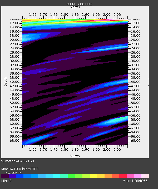
| Estimated Moho Depth: |
10.0 km |
| Estimated Crust Vp/Vs: |
2.06 |
| Assumed Crust Vp: |
6.245 km/s |
| Estimated Crust Vs: |
3.028 km/s |
| Estimated Crust Poisson's Ratio: |
0.35 |
|
| Radial Match: |
84.82158 % |
| Radial Bump: |
334 |
| Transverse Match: |
76.56663 % |
| Transverse Bump: |
400 |
| SOD ConfigId: |
25131211 |
| Insert Time: |
2021-08-13 17:41:18.926 +0000 |
| GWidth: |
2.5 |
| Max Bumps: |
400 |
| Tol: |
0.001 |
|

Signal To Noise
| Channel | StoN | STA | LTA |
| TX:CRHG:00:HHZ:20210730T17:17:14.010003Z | 38.948776 | 4.6652904E-6 | 1.1978015E-7 |
| TX:CRHG:00:HH1:20210730T17:17:14.010003Z | 1.7345064 | 1.2932156E-6 | 7.455813E-7 |
| TX:CRHG:00:HH2:20210730T17:17:14.010003Z | 8.076888 | 1.4970001E-6 | 1.8534367E-7 |
| Arrivals |
| Ps | 1.8 SECOND |
| PpPs | 4.6 SECOND |
| PsPs/PpSs | 6.4 SECOND |


