You are here: Home > Network List > TX - Texas Seismological Network Stations List
> Station DRZT Darrouzett > Earthquake Result Viewer
DRZT Darrouzett - Earthquake Result Viewer
| Earthquake location: |
Peru-Ecuador Border Region |
| Earthquake latitude/longitude: |
-4.9/-80.6 |
| Earthquake time(UTC): |
2021/07/30 (211) 17:10:19 GMT |
| Earthquake Depth: |
33 km |
| Earthquake Magnitude: |
6.2 Mww |
| Earthquake Catalog/Contributor: |
NEIC PDE/us |
|
| Network: |
TX Texas Seismological Network |
| Station: |
DRZT Darrouzett |
| Lat/Lon: |
36.44 N/100.30 W |
| Elevation: |
791 m |
|
| Distance: |
45.1 deg |
| Az: |
337.442 deg |
| Baz: |
151.704 deg |
| Ray Param: |
0.07144119 |
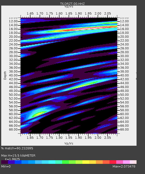
| Estimated Moho Depth: |
15.5 km |
| Estimated Crust Vp/Vs: |
1.96 |
| Assumed Crust Vp: |
6.483 km/s |
| Estimated Crust Vs: |
3.303 km/s |
| Estimated Crust Poisson's Ratio: |
0.32 |
|
| Radial Match: |
90.232895 % |
| Radial Bump: |
400 |
| Transverse Match: |
72.78776 % |
| Transverse Bump: |
400 |
| SOD ConfigId: |
25131211 |
| Insert Time: |
2021-08-13 17:41:22.506 +0000 |
| GWidth: |
2.5 |
| Max Bumps: |
400 |
| Tol: |
0.001 |
|

Signal To Noise
| Channel | StoN | STA | LTA |
| TX:DRZT:00:HHZ:20210730T17:18:01.844994Z | 40.46065 | 6.3835932E-6 | 1.5777286E-7 |
| TX:DRZT:00:HH1:20210730T17:18:01.844994Z | 11.990223 | 1.7043817E-6 | 1.4214763E-7 |
| TX:DRZT:00:HH2:20210730T17:18:01.844994Z | 15.40846 | 2.466196E-6 | 1.6005467E-7 |
| Arrivals |
| Ps | 2.4 SECOND |
| PpPs | 6.7 SECOND |
| PsPs/PpSs | 9.1 SECOND |


