You are here: Home > Network List > TX - Texas Seismological Network Stations List
> Station SNAG San Augustine > Earthquake Result Viewer
SNAG San Augustine - Earthquake Result Viewer
| Earthquake location: |
Komandorskiye Ostrova Region |
| Earthquake latitude/longitude: |
55.4/166.5 |
| Earthquake time(UTC): |
2018/01/25 (025) 02:10:33 GMT |
| Earthquake Depth: |
8.8 km |
| Earthquake Magnitude: |
6.2 Mww |
| Earthquake Catalog/Contributor: |
NEIC PDE/us |
|
| Network: |
TX Texas Seismological Network |
| Station: |
SNAG San Augustine |
| Lat/Lon: |
31.52 N/94.18 W |
| Elevation: |
84 m |
|
| Distance: |
69.6 deg |
| Az: |
64.022 deg |
| Baz: |
323.102 deg |
| Ray Param: |
0.055527464 |
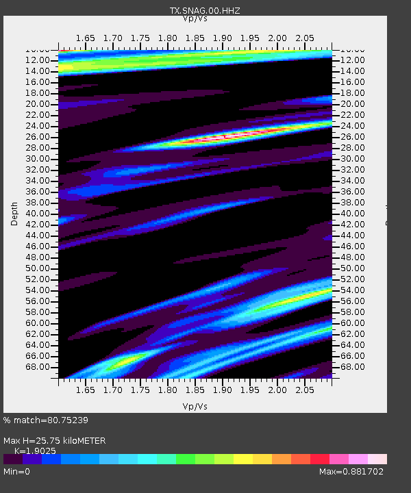
| Estimated Moho Depth: |
25.75 km |
| Estimated Crust Vp/Vs: |
1.90 |
| Assumed Crust Vp: |
5.738 km/s |
| Estimated Crust Vs: |
3.016 km/s |
| Estimated Crust Poisson's Ratio: |
0.31 |
|
| Radial Match: |
80.75239 % |
| Radial Bump: |
400 |
| Transverse Match: |
72.64755 % |
| Transverse Bump: |
368 |
| SOD ConfigId: |
2546091 |
| Insert Time: |
2018-02-08 02:15:54.692 +0000 |
| GWidth: |
2.5 |
| Max Bumps: |
400 |
| Tol: |
0.001 |
|
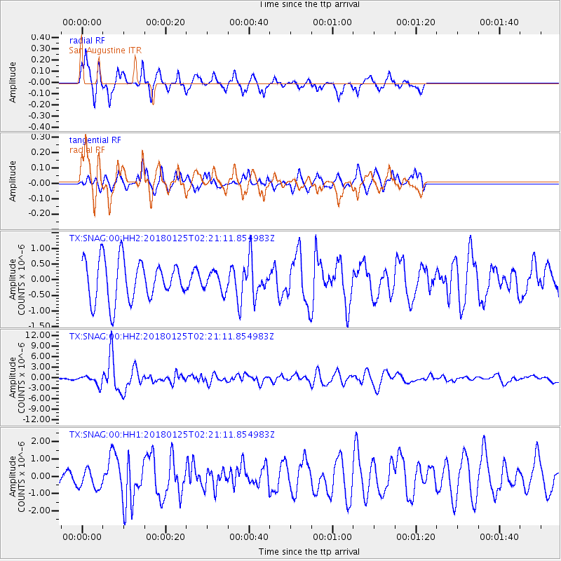
Signal To Noise
| Channel | StoN | STA | LTA |
| TX:SNAG:00:HHZ:20180125T02:21:11.854983Z | 4.058492 | 1.3996266E-6 | 3.448637E-7 |
| TX:SNAG:00:HH1:20180125T02:21:11.854983Z | 1.3006546 | 5.5272295E-7 | 4.2495748E-7 |
| TX:SNAG:00:HH2:20180125T02:21:11.854983Z | 0.4853309 | 3.13762E-7 | 6.464909E-7 |
| Arrivals |
| Ps | 4.2 SECOND |
| PpPs | 13 SECOND |
| PsPs/PpSs | 17 SECOND |


