You are here: Home > Network List > TX - Texas Seismological Network Stations List
> Station PB19 West of Imperial > Earthquake Result Viewer
PB19 West of Imperial - Earthquake Result Viewer
| Earthquake location: |
Peru-Ecuador Border Region |
| Earthquake latitude/longitude: |
-4.9/-80.6 |
| Earthquake time(UTC): |
2021/07/30 (211) 17:10:19 GMT |
| Earthquake Depth: |
33 km |
| Earthquake Magnitude: |
6.2 Mww |
| Earthquake Catalog/Contributor: |
NEIC PDE/us |
|
| Network: |
TX Texas Seismological Network |
| Station: |
PB19 West of Imperial |
| Lat/Lon: |
31.30 N/103.10 W |
| Elevation: |
782 m |
|
| Distance: |
41.9 deg |
| Az: |
330.66 deg |
| Baz: |
145.226 deg |
| Ray Param: |
0.07340208 |
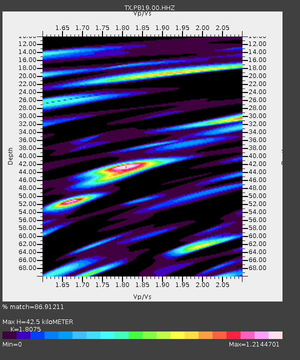
| Estimated Moho Depth: |
42.5 km |
| Estimated Crust Vp/Vs: |
1.81 |
| Assumed Crust Vp: |
6.121 km/s |
| Estimated Crust Vs: |
3.386 km/s |
| Estimated Crust Poisson's Ratio: |
0.28 |
|
| Radial Match: |
86.91211 % |
| Radial Bump: |
400 |
| Transverse Match: |
71.87019 % |
| Transverse Bump: |
400 |
| SOD ConfigId: |
25131211 |
| Insert Time: |
2021-08-13 17:42:25.791 +0000 |
| GWidth: |
2.5 |
| Max Bumps: |
400 |
| Tol: |
0.001 |
|

Signal To Noise
| Channel | StoN | STA | LTA |
| TX:PB19:00:HHZ:20210730T17:17:36.485009Z | 43.73534 | 5.4441302E-6 | 1.2447897E-7 |
| TX:PB19:00:HHN:20210730T17:17:36.485009Z | 12.010919 | 2.9254147E-6 | 2.4356294E-7 |
| TX:PB19:00:HHE:20210730T17:17:36.485009Z | 7.66167 | 1.524736E-6 | 1.9900831E-7 |
| Arrivals |
| Ps | 6.0 SECOND |
| PpPs | 18 SECOND |
| PsPs/PpSs | 24 SECOND |


