You are here: Home > Network List > TX - Texas Seismological Network Stations List
> Station SMWD Samnorwood > Earthquake Result Viewer
SMWD Samnorwood - Earthquake Result Viewer
| Earthquake location: |
Peru-Ecuador Border Region |
| Earthquake latitude/longitude: |
-4.9/-80.6 |
| Earthquake time(UTC): |
2021/07/30 (211) 17:10:19 GMT |
| Earthquake Depth: |
33 km |
| Earthquake Magnitude: |
6.2 Mww |
| Earthquake Catalog/Contributor: |
NEIC PDE/us |
|
| Network: |
TX Texas Seismological Network |
| Station: |
SMWD Samnorwood |
| Lat/Lon: |
35.10 N/100.24 W |
| Elevation: |
704 m |
|
| Distance: |
43.9 deg |
| Az: |
336.585 deg |
| Baz: |
151.125 deg |
| Ray Param: |
0.07218491 |
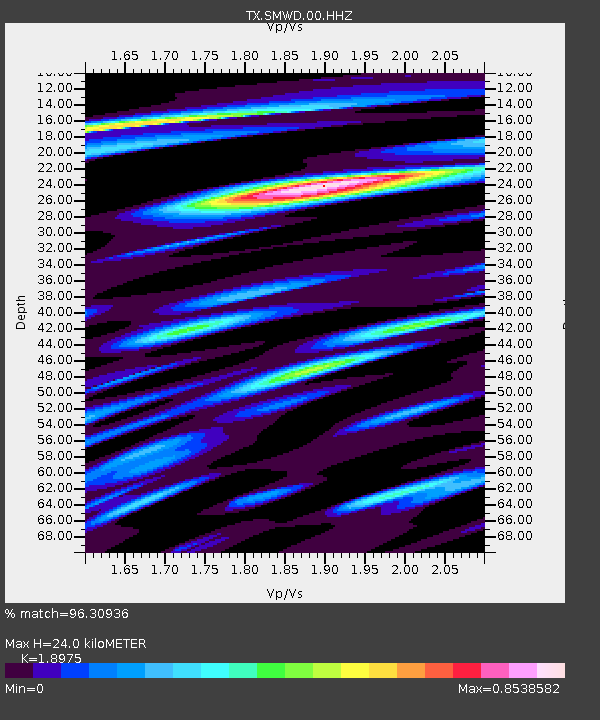
| Estimated Moho Depth: |
24.0 km |
| Estimated Crust Vp/Vs: |
1.90 |
| Assumed Crust Vp: |
6.426 km/s |
| Estimated Crust Vs: |
3.387 km/s |
| Estimated Crust Poisson's Ratio: |
0.31 |
|
| Radial Match: |
96.30936 % |
| Radial Bump: |
298 |
| Transverse Match: |
90.945335 % |
| Transverse Bump: |
389 |
| SOD ConfigId: |
25131211 |
| Insert Time: |
2021-08-13 17:42:44.614 +0000 |
| GWidth: |
2.5 |
| Max Bumps: |
400 |
| Tol: |
0.001 |
|

Signal To Noise
| Channel | StoN | STA | LTA |
| TX:SMWD:00:HHZ:20210730T17:17:52.320Z | 80.11778 | 6.9999965E-6 | 8.7371326E-8 |
| TX:SMWD:00:HH1:20210730T17:17:52.320Z | 57.87598 | 4.6283662E-6 | 7.997041E-8 |
| TX:SMWD:00:HH2:20210730T17:17:52.320Z | 25.02156 | 2.387408E-6 | 9.541403E-8 |
| Arrivals |
| Ps | 3.6 SECOND |
| PpPs | 10 SECOND |
| PsPs/PpSs | 14 SECOND |


